
The Calderdale way is a 50 mile circular walk with link paths that allow you to break it up into smaller circular walks. It is a great way to explore the landscape and some lovely old routes around the area. Please remember that many of the footpaths go through working farms, so be respectful of this as you pass through.
Visit Calderdale have made this short film about the Calderdale way.

ACCESSING THE ROUTE
You can start the route anywhere that is convenient. The Link paths provide a walking route from public transport. There are further options in the detailed directions.
NAVIGATING THE ROUTE
The OS OL21 South Pennines Explorer map covers most of the route and the Explorer map 288 covers the Eastern end. The main Calderdale Way route is marked as a green dotted line with diamond shaped lozenges, the link paths are not specially marked.
You can also use a combination of:
- Chris Goddard’s annotated drawn map. This can be purchased directly from Chris’s Website, Todmorden Information Centre, The Bookcase in Hebden Bridge and many other outlets.
- Detailed written directions from this web page which you can download to your phone or print off.
- Downloaded GPX maps of the Link paths from this web page
- Following the Calderdale Way dedicated waymarks.

DETAILED WALKING DIRECTIONS FOR THE MAIN ROUTE
In 2024 we wrote a set of detailed directions for the whole of the main route. For each section we include:
- Detailed updated directions (turn left, follow the path etc)
- Up to date bus details (see WY metro website for timetables)
- Up to date refreshment stops (with telephone numbers to check if open) and other facilities
- How you can walk the main route in sections.
- Points of interest.
Mobile friendly directions to use on your phone
- Section 1 Brighouse to West Vale
- Section 2 West Vale to Norland Moor
- Section 3 Norland Moor to Ripponden
- Section 4 Ripponden to Cragg Vale
- Section 5 Cragg Vale to Lumbutts
- Section 6 Lumbutts to Todmorden
- Section 7 Todmorden to Blackshawhead
- Section 8 Blackshaw Head to Heptonstall
- Section 9 Heptonstall to Pecket Well
- Section 10 Pecket Well to Luddenden Dean
- Section 11 Luddenden Dean to Brockholes
- Section 12 Brockholes to Shibden Valley
- Section 13 Shibden to Norwood Green
- Section 14 Norwood Green to Brighouse
PDF files to download or print
- Section 1 Brighouse to West Vale
- Section 2 West Vale to Norland Moor
- Section 3 Norland Moor to Ripponden
- Section 4 Ripponden to Cragg Vale
- Section 5 Cragg Vale to Lumbutts
- Section 6 Lumbutts to Todmorden
- Section 7 Todmorden to Blackshawhead
- Section 8 Blackshaw Head to Heptonstall
- Section 9 Heptonstall to Pecket Well
- Section 10 Pecket Well to Luddenden Dean
- Section 11 Luddenden Dean to Brockholes
- Section 12 Brockholes to Shibden Valley
- Section 13 Shibden to Norwood Green
- Section 14 Norwood Green to Brighouse
LINK PATHS
There are thirteen link paths that give you access to the main route. The starting points are all served by public transport. They make it able to do circular walks completing the Calderdale Way in short sections. They can also be used if you need to shorten your walk because of weather deterioration etc.
As the link paths are not marked on the OS map, we have produced GPX versions for each of them (see below)
The descriptions contain information from Open Street Map, which is made available here under the Open Database License (ODbL).
Sowerby Bridge to Norland Moor (middle of section 3) – 1.5 miles
Luddendenfoot to Catherine Slack (middle of section 4) – 2.8 miles
Mytholmroyd to Cragg Vale (middle of section 4) – 1.8 miles
Castle Street to Lumbutts (beginning of section 6) – 1 mile
Todmorden to Hole Bottom (middle of section 7) – 1 mile
Jumble Hole to Hippins (start of section 7) – 1 mile
Hebden Bridge to Heptonstall (start of section 9) – 1 mile
Hebden Bridge to Allswell Farm (near start of section 10) – 2 miles
Mytholmroyd to Crow Hill (middle of section 10) – 1.5 miles
Luddendenfoot to Jerusalem Lane (start of section 11) – 2.3 miles
Wainstalls to Moorfield Farm (middle of section 11) – 0.5 miles
Halifax to Simm Carr (start of section 13) – 2.3 miles
Halifax to Salter Hebble (near start of Section 1) – 2.3 miles
Downloading Link Path GPX maps
Unfortunately Word Press won’t let us add GPX files to the website, so you will need to download and unzip this file to get GPX tracks for the link paths.
You can then import them into the mapping software of your choice. you may be able to import the zip file itself. Otherwise unzip it and import the files individually. If you are having issues unzipping the file on your phone try doing it on your computer and uploading them to the cloud. You can then access them on your phone.
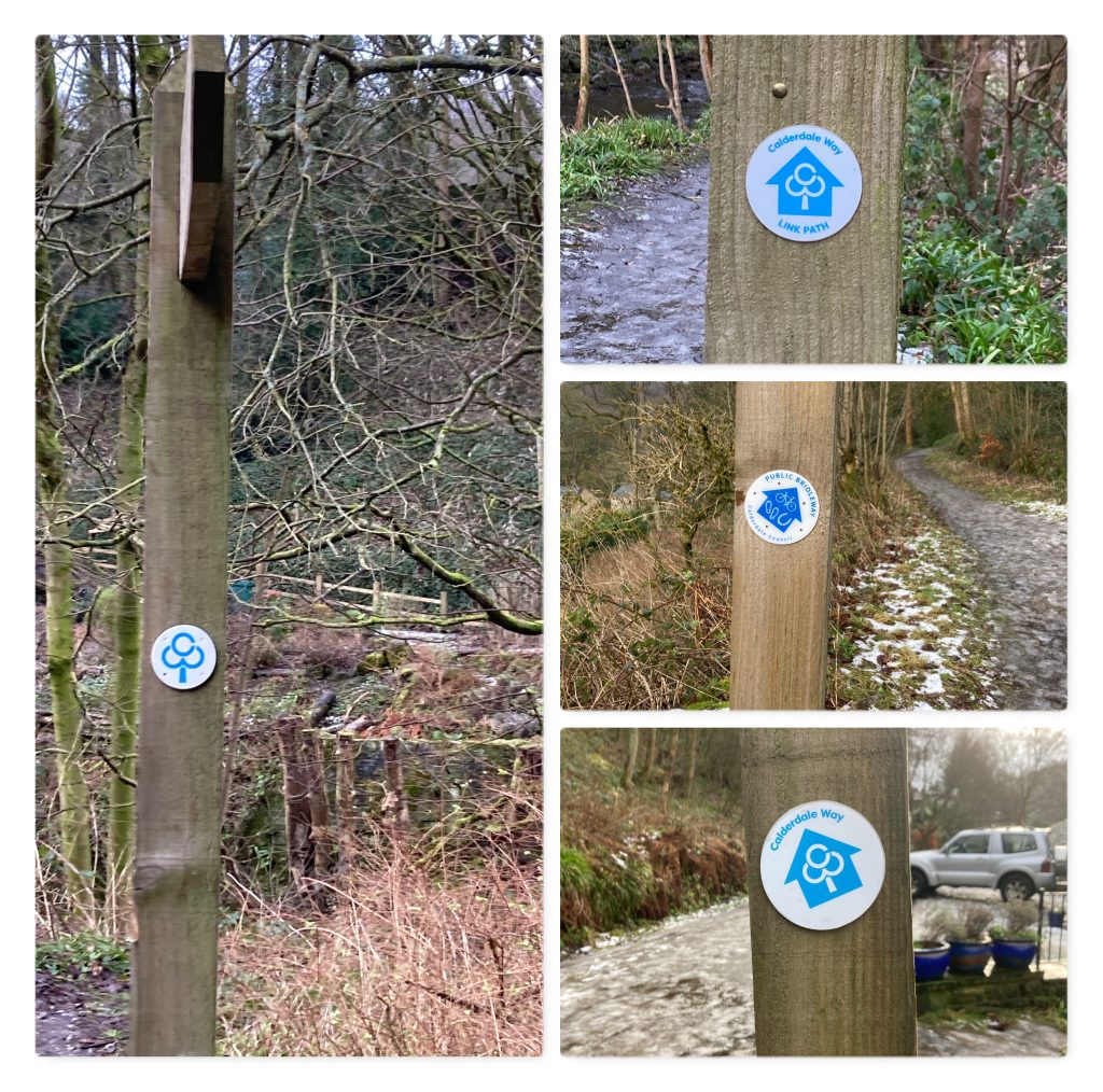
WAYMARKING
CROWS (Community Rights of Way Services) have recently completed re-waymarking the route. Thanks to Ramblers Holidays Trust and Calderdale Ramblers for supporting this work.
You will see several kinds of waymarks on the route:

FEEDBACK & PROBLEMS MET ON THE ROUTE
If any of the directions are wrong or misleading, or anything on this page needs correcting, please tell us.
If the condition or waymarking of any part of the route causes concern, please report the issue to CROWS (Community Rights of Way Services) using their simple form.