
Distance: About 3 km or 2 miles
Time: About 1 to 1½ hours one way (including refreshment and view stops). The length can be shortened.
Paths: Lanes and good footpaths
Strenuousness: The whole route is pretty flat
Waymarking: There are waymarks both ways along the whole route
Option 1 Ripponden to Rishworth and bus back
Buses back to Ripponden are very infrequent, check times before you set off.
Option 2 Ripponden to Rishworth and walk back
About 5k and about 2 hours.
Option 3 Bus to Rishworth and walk to Ripponden
Buses to Rishworth are very infrequent, check times before you set off.
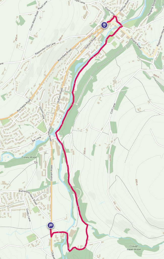
Walking from Ripponden to Rishworth
1) Starting from the Last Post Social Dining on Oldham Road (at the top of the map), head towards the traffic lights and cross over the Elland Road on your right to the fine milestone.
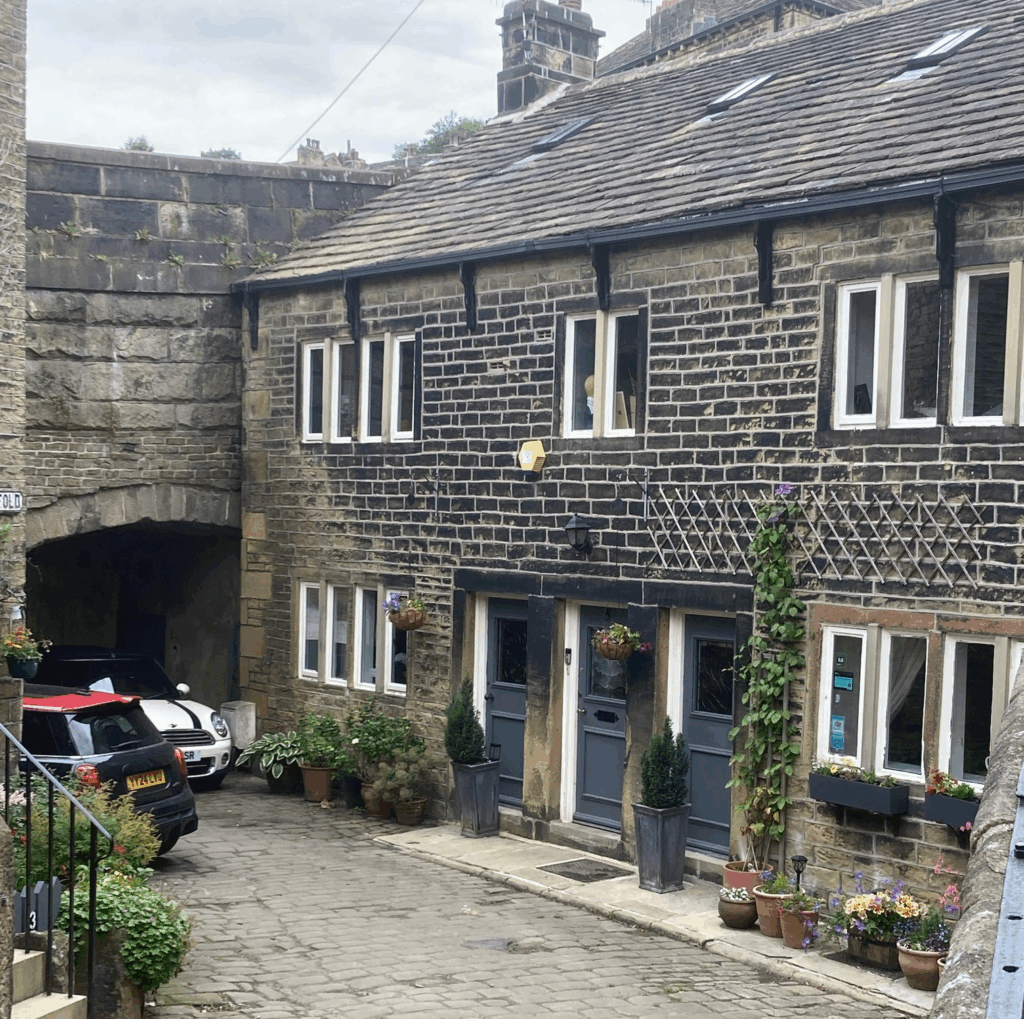
2) About 30 metres further on, turn right down a cobbled lane called Priest Lane. Pass the Old Bridge Inn and go over the ancient Packhorse Bridge which crosses the river Ryburn.
In the early 1500’s a William Firth bequeathed 7/6d for the building of a stone bridge. Nearby is the Old Bridge Inn dating back to 1307. The current building dates from the 16th century. Note the village stocks outside the pub.

3) Immediately you have crossed the bridge take the narrow lane on the right that doubles back passing a cluster of houses called Millfold. Go straight on under the road bridge and continue along the lane passing some old industrial buildings, once the site of Ripponden Mills. The end of the lane leads into the playing field where you follow the path around to the right.
4) Come out of the playing field and carry straight ahead along a tarmac lane which runs alongside the river, passing some houses and a campsite on your left.
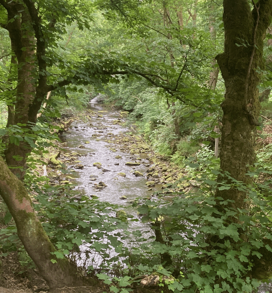
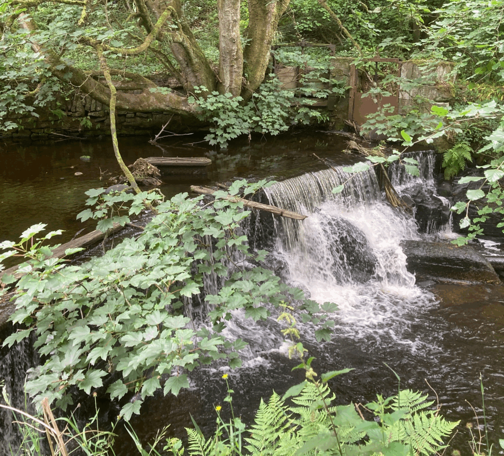
Early textile mills used the River Ryburn for water power. If you look over to the opposite bank as you walk along, you can see the remains of the old mill dams fed by a series of weirs.
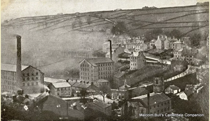
By 1811 nine cotton mills were in operation in the Ripponden making it a thriving commercial centre. By the mid nineteenth century most of the mills had gone over to steam, great for productivity, bad for air quality!
5) Where the tarmac lane bears to the left go straight ahead, keeping the river on your right. Just past the metal Pretoria Bridge, turn left up the steps and onto a rough path (going over the bridge will take you back up to the main road). Keep straight ahead on this path, through a stone gap stile.

At the gap stile and waymark post you can turn left to take a short detour up to the old railway line.
The branch line between Sowerby Bridge and Rishworth was opened by the Lancashire and Yorkshire Railway in 1881 but was closed to passenger traffic in 1929 apart from excursion trips. The section between Rishworth and Ripponden closed for freight in 1953 and the line between Ripponden and Sowerby Bridge closed completely on 1st September 1958. There had been an earlier plan to extend the tunnel through Blackstone Edge to Littleborough but it was never realised.
6) After 600 metres you come out on to Slitheroe Bridge where you keep straight ahead on a lane still following the river.
Slitheroe Bridge is at the confluence of the River Ryburn and Booth Wood Clough. A massive trestle bridge, 20 foot wide built of timber with stone setts paving the roadway linked Rishworth Railway station with the Oldham Road. When the branch line was closed this bridge was demolished, but there is still evidence of its existence.
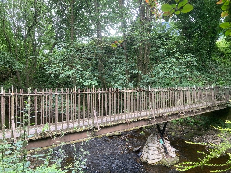
7) After 250 metres, where the track turns sharply up to the left, keep straight ahead on a narrow path just left of Holme House. The path gently descends and you cross a footbridge.
8) Keep on the path to the left, through the field. Go through a gate into the next field, turn right which will take you down to a pylon and the river and cross into the car park of Rishworth Palace (formerly Rishworth Mill).
Rishworth Mill was the successor to earlier mills on the same site, including corn and fulling mills. The previous mill, which was destroyed by floods in 1857, was replaced by the current mill, built between 1862 and 1865, during the ‘Cotton Panic’ which resulted from the American Civil War. The mill was renamed Rishworth Palace and converted to flats in 1994.
9) Go around the building and then turn right over the bridge and up the access road. Keep straight ahead on a narrow path that will take you up to the main road.
As you walk up the hill, you can see on the left what remains of the old mill in the form of the Heathfield School swimming pool
10) When you reach the main road look over to your right where there’s a turning circle and just beyond that is a bus stop for the 586 bus that will take you back to Ripponden.
More about the heritage of the area
Other walks around Ripponden and the Ryburn Valley
Local walk leaflets are available in the Wild Goose Ripponden and the Post Office at Barkisland (other outlets are listed on the Heart of the Pennines website).
You will find lots of walks in the area on the Heart of the Pennines website. Just select Ripponden from the search menu.
Walking from Ripponden Rishworth and back
Follow the directions above but finish at point 9 and start and point 2 below. This will take you about 2 hours.
Walking from Rishworth to Ripponden
The Ripponden bus stop for the 586 bus to Rishworth is opposite the Doctors surgery at the Halifax end of Ripponden. The buses are very infrequent. Check times before you set off. Ask to be put off at Rishworth Palace (at the bottom of the map).

1) From the bus stop, continue up the road and turn left down the access road to Rishworth Palace. At the bottom, turn left around the building and then right into a car park.
Rishworth Mill was the successor to earlier mills on the same site, including corn and fulling mills. The previous mill, which was destroyed by floods in 1857, was replaced by the current mill, built between 1862 and 1865. The mill was renamed and converted to flats in 1994
2) Take a footpath going off to the left of the car park, towards a pylon. The path heads towards a gateway where you turn left along a path which ends at a foot bridge (just before the pylon there is an unofficial riverside path that also leads to the footbridge)
3) Cross the foot bridge on to a narrow path which passes by the side of Holme House and comes out at a bend in a track. Head left slightly downhill on the track.
4) The track ends at a junction at Slitheroe Bridge where you go straight ahead through a gap stile to join a path alongside the River Ryburn. You follow this for 600 metres.
At a gap stile and waymark post, you can turn right to take a short detour up to the old railway line between Sowerby Bridge and Rishworth.
This was opened by the Lancashire and Yorkshire Railway in 1881 but was closed to passenger traffic in 1929 apart from excursion trips. The section between Rishworth and Ripponden closed for freight in 1953 and the line between Ripponden and Sowerby Bridge closed completely on 1st September 1958. There had been an earlier plan to extend the tunnel through Blackstone Edge to Littleborough but it was never realised.
5) The main route drops down some step to the metal Pretoria Bridge where you turn right continuing along the river. Where the track becomes a tarmac lane keep straight ahead passing a campsite and some houses on your right.

Early textile mills used the River Ryburn for water power. If you look over to the opposite bank you can see the remains of the old milldams fed by a series of weirs.
By 1811 nine cotton mills were in operation in the Ripponden making it a thriving commercial centre. By the mid nineteenth century most of the mills went over to steam, great for productivity, bad for air quality!

6) The tarmac lane comes out at the playing fields on your left, go through the entrance and follow the path around the edge to the exit. Go straight ahead down the cobbled lane passing some old industrial buildings.
7) At the end, go under the road bridge past a cluster of buildings at Mill Fold. Turn sharp left over the old packhorse bridge, passing the Old Bridge Inn.
The River Ryburn is crossed by a 16th-century packhorse bridge. Nearby is the Old Bridge Inn dating back to 1307. The current building dates from the 16th century.

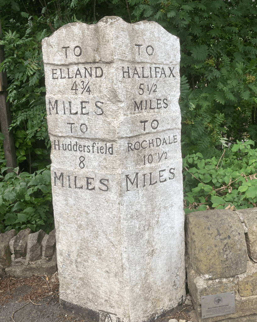
8) Go up the cobbled Priest Lane and turn left at the main road. Cross the road to Elland on your left and head towards the traffic lights. Just Past the lights you will reach the end of the walk at the Last Post Social Dining.
Other walks around Ripponden and the Ryburn Valley
Local walk leaflets are available in the Wild Goose Ripponden and the Post Office at Barkisland (other outlets are listed on the Heart of the Pennines website).
You will find lots of walks in the area on the Heart of the Pennines website. Just select Ripponden from the search menu.