
From the mid-19th century, Cornholme was a thriving industrial hub. This walk will show you many lost and forgotten mills, but you will also get great views of the dramatic valley.
Click on the image below to download the booklet. Alternatively use these mobile friendly directions.
Mobile Friendly Directions
Bus and train access to the route – The 591 and 592 buses through Cornholme go to and from Burnley, Todmorden, Hebden Bridge and Halifax.
Length and time – About 3.5 miles (5½ km). It should take you about 2 hours plus stops.
Gradients – Mainly flat, but from points 12-13 there is a climb up a steep hillside then a steep slope down.
Terrain – Much of the route is mainly on the pavement or on good tracks. From point 10 onwards parts can be very slippery, especially when it’s wet. If you don’t fancy that, you can return along Burnley Road back to our start position at Vale Baptist Church.
Obstacles – There are 2 stiles to climb over.
Facilities – Sandwiches at Moor Fillings (point 4 on map), meals & drinks at the Glen View pub (just before point 8 on the map), drinks at the Roebuck pub (point 9 on the map).
Following the Walk
Start from Vale Baptist Chapel Churchyard, Cornholme
OS ref SD 912 262, W3W ref ///star.prep.query
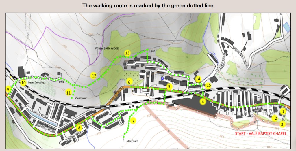
1) Vale Baptist Chapel
Vale Baptist Church was an offshoot of the one at Shore. This church was originally much larger until the main church was demolished in 1967. The current building was the Sunday School, also known as the “People’s College”
where illiterate mill workers were taught to read and write.
2) James Standing’s Grave (1848-1878)
Facing the church, the Obelisk grave for James Standing is at the top left-hand corner. Standing was a Bobbin Turner
at Portsmouth Mill aged 14 then, 10 years later, a school master and author of books and articles on the 19th century local Lancashire dialect.
3) Vale Mill (Cotton and Bobbins)
Vale Mill was built by William Clegg in 1854 and changed hands and usage regularly. It had two sheds on the site, but now all that remains is a pile of the massive stones that the steam engine used to stand on.
Come out of the community garden, cross over and turn left along the main road, past St. Michael’s church on the left, the old school on the right and the Cornholme Grocers. After 500 metres Moor Fillings is on your right (get your sandwiches for later) and opposite is the magnificent four storey Frostholme Mill.
4) Frostholme Mill (Cotton)
The original Mill was built in 1861 until the premises were devastated by fire in 1898 after which the current buildings were built. The fire caused some £5m in damage (in today’s money). The Mill had a long industrial life finally closing as a furniture manufacturer in 2019. Now walk along the main road under the railway bridge.
5) Cornholme Mill (Bobbins)
Cornholme Mill was massive – on both sides of the road with a connecting bridge. It covered the site of the Bobbin Mill Close housing estate. The original mill burned down in 1888 allowing the owners, the Wilson family, to build a brand new one on the site. Wilson’s were an innovative company and held several patents for bobbins and shuttles which they leased to other mills.
Double decker buses couldn’t use the Burnley to Todmorden route due to the low bridge across the road, so it was quickly demolished when the mill closed.
The Wilsons were very involved with Cornholme, their graves still lie in Mount Zion United Free Methodist Church. They were a large company with another mill at Garston on Merseyside which became the headquarters in 1902. They even had a fleet of schooners (later steamers) to bring wood for bobbins from Ireland to Garston.
Keep walking for 250m, past Daisy Bank Street and Brown Birks Street on your right, until you reach the disused churchyard of Mount Zion Methodist Church.
6) Mount Zion United Free Methodist Church
The Free Methodists were a non-conformist denomination which was formed by re-uniting many small groups. Then, in 1907, they joined with other Methodist groups to form the United Methodist Church. This was a huge Church with an even bigger Sunday School next to it. Now, little remains of either structure. Go up the steps (take care and use the hand rail). At the top follow the path ahead. On the right is a war memorial and on the left the memorial to the Wilsons who owned the Bobbin Mill.
As the path bends right, on your left is the gravestone of John Rhodes who lived in the mid-19th century. You will see he had grandchildren who died in Australia and Russia as well as in Bury, Lancashire. His grandson, Jared Priestley, was a missionary and miner who followed the Gold Rush to Australia. On his return he took employment setting up Cotton Mills near Moscow for the Tsar. He ended his days working as an Onsetter in a mill in Bury. A man who, with his family, travelled the world.
Further up the path heading towards some steps, on the left you will also see a large gravestone to Abraham Lincoln Law, named after the US president. If you’ve time, wander round and see what else you can find. There are ex-Todmorden Mayors, memorials to soldiers lying in ‘foreign fields’, missionaries who worked in China and many more.
Now retrace your steps to Burnley Road and go back down the road for 200 metres. On your right, just before Bobbin Mill Close, you will see a bridge under the railway line. Cross the road (take care) and go under it, then turn right up the track. Pass an allotment, then at a fork bear left up the path to a stile. Cross it and go a little farther up and you will see some strange mounds on the hillside to your left.
7) Portsmouth Fire Clay Works
These mounds are the remains of Fireclay Works. Fireclay is often discovered near coal mines and is used to make fire bricks – heat resistant and used in homes and industry.
Retrace your steps to the allotment and turn left towards the housing estate. The estate is on the site of the works and railway sidings that used to take the fireclay products away. Walk along Mount Pleasant Street to rejoin Burnley
Road. Turn left to the Glen View pub (excellent beer and food and a great collection of old photos of Cornholme).
8) Carrfield Mill (Cotton)
Surrounding the Glen View pub is a new housing estate on the site of Carrfield Cotton Mill. In 1867 the owners were fined at least three times for employing under-age children in the mill. The mill was demolished in 2006.
Walk up the main road for about 500m to the Roebuck Inn (contact 01706 816179 for opening hours) with Portsmouth Mill opposite.
9) Portsmouth Mill (Cotton)
Portsmouth Mill was established in the 1840’s and was in an advantageous position due to the river which ran down the clough at the back. James Standing (the scholar buried at Vale) worked in this mill aged 14. The steam
engine for the mill had its chimney high on the hill with the flue being part of the chimney. The mill has recently been converted into flats. It was also the destination for coal brought down the Beater Clough Incline (this is covered in the “Stone, Coal and Water” walk).
Retrace your steps and turn left on to Station Parade. At the end go through the level crossing gates, taking care to follow the instructions.
10) Portsmouth Station
The station site was towards Todmorden from the level crossing. It had sidings going to the small row of buildings in the distance. These housed bobbins from Wilson’s Cornholme Mill ready for shipping to worldwide markets. The station closed in 1938.
From the crossing go up the side of the red brick mill and keep straight ahead with The Lodge on your left and the Allotments on your right. The three large houses you pass were once the homes of mill managers. After 200m cross over a stile and walk up to the Burnley Way post on the lower part of the hill. Be careful – it can be slippery. The Burnley Way goes up to the left, but you can carry straight ahead on a well-used path for 20 metres and go over to the fence and take in the great view over the village and the valley.
11) Coal in Cornholme and Portsmouth
This is a great place to look at the Fireclay workings on the other side of the valley and above them, near the wind turbines but out of sight, are the mines of Todmorden Moor. The last working mine closed in 2014. As you look round towards Burnley, along the road, at the end of the wooded area is Rattan Clough.
This was the scene of drama in October 1947 when, after heavy rain, over a million tons of mine waste rushed down the Clough, engulfing the road and threatening to do the same with the railway line. The Cornholme Methodist Football Ground was in its path – this stemmed the tide and the line remained unaffected. Even more luckily, no-one was injured by the mud.
In the distance, as the railway and road disappears towards Burnley, is the site of Copy Pit which gave its name to this part of the line. Copy Pit had two distinctive headframes and closed in 1964.
You have two choices here:
– If you are not a confident or experienced walker, we suggest you retrace your steps to the station crossing, then walk back down the main road to just before the railway bridge. There you turn left and immediately turn right just before the Old Library. You can pick up the walk
just before point 14.
– If you like a challenge, you can continue ahead towards Windy Bank Wood. Parts of the path are very slippery, especially at the bottom. There is also a wet stream crossing and a slippery ginnel.
12) The Cableway
Just before you enter the wood, carefully look around. You may be able to see some loose rocks and a metal stanchion. This is all that remains of a cable way which brought down coal from pits higher up to the coal yard near Mount Zion Churchyard.
13) Windy Bank Wood and Bankwell Coal Level
The path goes down through the wood and takes in the rather lovely woodland scene. In the corner above the new houses is a small mine level (gated). Take care in the wet.
Bankwell Colliery opened in 1811 and was worked intermittently through to 1921. It produced coal mainly for local needs. There is little left now but this upper level remains along with an impressive level (sealed) down on the main road. All local mines are in a perilous state and should not be entered.
After crossing the stream (take great care as the mud can be quite deep) the path goes along the fence line above the new houses. After 200m you will see a yellow top post and a small gate on the right with a cobbled ginnel (alley)
leading downwards. Hold on to the fence as it can be slippery when wet. Remember to shut the gate. At the bottom turn left and follow the road down towards the railway bridge.
14) Calder Vale Mill (Cotton and Bobbins)
Calder Vale Mill was built around 1880. It operated initially as a cotton mill but through a succession of owners it made weaving equipment – shuttles, bobbins and pickers. It was mostly demolished in 2009 and is now the site of a small housing estate. The remaining structure is used by a building company.
15) Spring Wood Mill (Bobbins and Cotton)
This Mill, originally built as a water powered mill in 1847, was eventually powered by a steam engine. All that’s left of it are some of the weaving sheds higher up the hill, used as small industrial units. The main buildings have been demolished and a house now stands in their place. After it stopped working, for a number of years the empty sheds were home to the Burnley Valley Flower Show.
In 1967 the railway line next to it was the scene of a serious accident when two goods trains collided and derailed, damaging the roof of the mill.
Go under the railway bridge and you are back at Frostholme Mill (point 4). Walk back along Burnley Road to the start point at Vale Baptist Church.
More about Cornholme’s History
If you want to know more about Cornholme and its history, here are a few suggestions that are easily available locally or online:
- Cornholme E-Trail – A walk with audio visual commentary for your phone is available at Tod Info Centre.
- Pennine Digital Archive with loads of great photos.
- Todmorden Moor Geology Trail has a trail map.
- Tod Antiquarians
- Todmorden Library has a local history section with books and pamphlets that you can browse.