
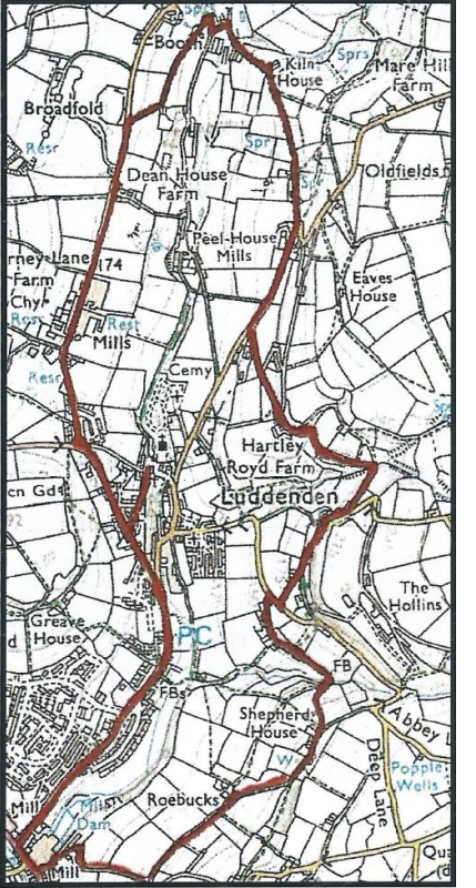
| Distance – 7 km or 4 miles (the route is shown in red on the map). Time – about 2½ to 3 hours (including refreshment and view stops) Paths – Mainly on tracks, lanes and quiet roads Strenuousness – There are two significant uphill sections Facilities – Lord Nelson pub (check opening times). The toilets in the car park at the start of the walk are now closed. Starting Point – Car park along Luddenden Lane, (O.S. Grid reference 04168 25731) There is a very good information board about the Luddenden area in the car park |
You can get a printed version of this booklet from Luddenden Conservation Society
Background
The Luddenden Valley is a wonderful place to examine a wide range of architectural styles going back to the 16th century. By the 17th century, the textile industry had become established in the valley.
Yeomen farmers (people just below the rank of gentry) were running a dual economy, where they were farming and also manufacturing wool textiles from their sheep. High quality cloth was being produced, which was being sold by merchants throughout this country and frequently abroad. Consequently, large fortunes were being made, which often went into building houses to match their new-found status. The Luddenden valley is said to have more fine 17th century houses than any other comparable area in the whole country.
Nearly all of the houses were built of stone, although in some cases an earlier wooden building was encased in stone in the 17th century. In contrast to the houses of these yeomen farmers, workers’ housing mainly consisted of a single room. The last one of these in the Luddenden valley was lived in until the beginning of the 20th century, and then demolished.
The textile industry gradually increased in importance, so by the last quarter of the 18th century, at the height of the handloom era, clothiers’ houses usually included an upper floor over the house for a workshop. Similarly, terrace houses for weavers working at home had rows of windows on the upper floor to give light for the looms
there.
The approximate age of many houses can be established from the material used on the roof. Blue Welsh slates only started to be used from about 1850 onwards, and before that time stone slates were used.
To reduce building costs and to increase the number of houses which could be built on a piece of land, the houses were back-toback in streets. Sometimes, cellar dwellings which had a separate entrance down some steps in front of the main house would also be included. These often consisted of a single room, with maybe a scullery.
On very steep land such as that in the Calder and Luddenden valleys generally, to construct back-to-back houses, a gallery had to be included to allow access to one side. A further peculiarity of these areas was the ‘top and bottom’ houses, where separate houses with their backs to earth would be built at a lower level underneath a row of houses.
In general, workers’ houses built in the second half of the 19th century were of a much better quality than those built in the 1840s and before. During the middle of the 19th century, the ‘model dwellings movement’ arose, which led to much more government intervention in building houses of a decent standard.
Walk directions and information about the houses
1) Turn right out of the car park, and bear left up New Road at the junction.
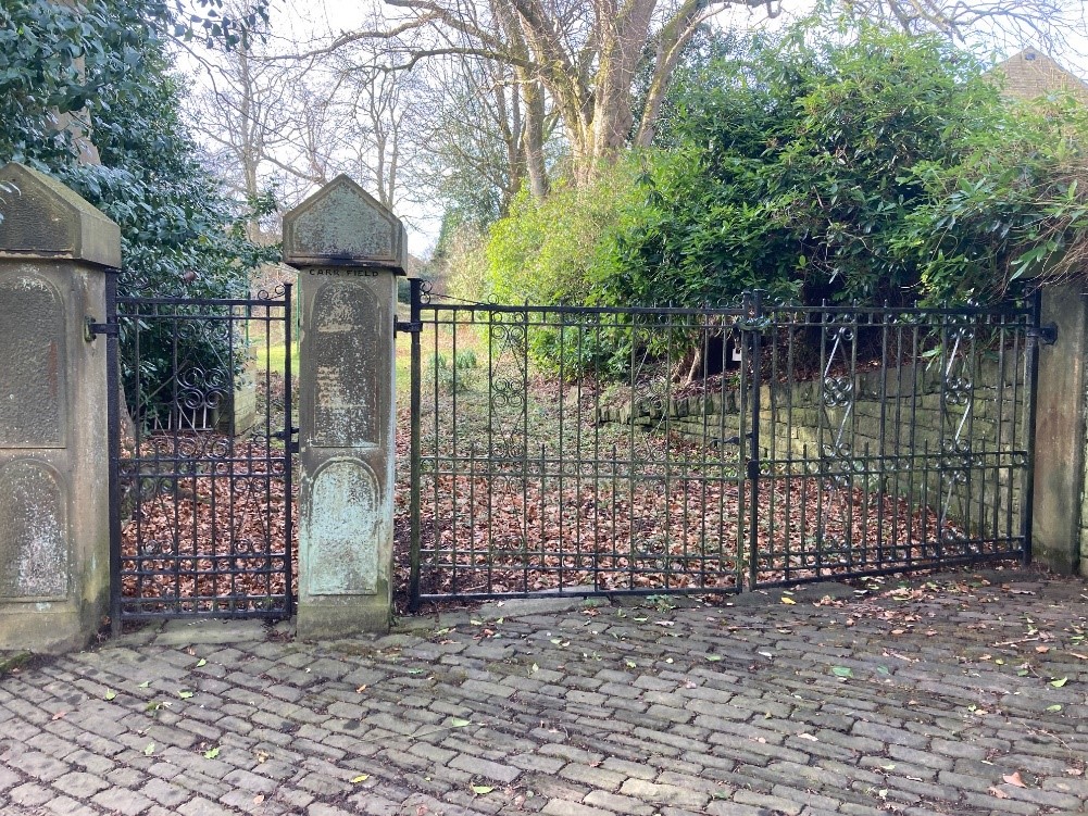
About 150 metres up the road, you come to Carr Field Drive.
This estate was built on the site of a mill owner’s house called Carr Field which was demolished in the 1970s. Only the fine gateway survives.
2) After 100 metres, turn right by the old school building called High Street, passing a chapel and Sunday school on your right, built in 1902.
Directly across the road is a terrace where you can see a good example of a cellar dwelling, Folly Cottage with its own gate down some steps at the front of the house. At one time, six people were living in the single room with a small scullery at the back.
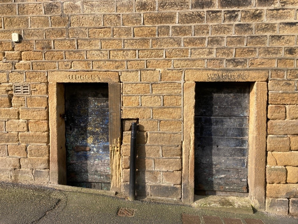
3) Walk down to the junction passing Saint Mary’s junior school built in 1856 by subscription now converted into dwellings. Watch out for the two doors which were lockups for miscreants for the two parishes.
At the junction with Old Lane, look up to see a terrace of houses up above you. This is Church Hill, and these listed buildings are an example of a row of early weavers’ cottages with a long row of windows upstairs.
4) Turn right down hill to arrive at the church and the Lord Nelson pub opposite.
The Lord Nelson Inn, originally built in 1634 (spot the error) as a house for Gregory Patchett (GFP) but which had been converted into an inn by 1740. Luddenden Old Library wasfounded here about 1776, and its most famous customer was Branwell Bronte, brother of the famous authors.
You could explore St Mary’s church or leave it when you do the companion walk about churches and chapels.
5) Retrace your steps back to New Road and turn right uphill passing the remains of an old Coop shop with pineapple finials above the windows.
On your right, the rough road called Thorn View you will see a row of houses, with a gallery above them to get around to the back to back houses at the rear of those on New Road itself where there is also another cellar house. You can also see that these houses when built were of a very good quality.
Continue uphill and shortly on your left you will see Hill Crest, which is relatively modern, was built in 1934 by public subscription as a house for the resident Luddenden nurse employed by the Luddenden and District Nursing Association.
Further up and set back, Wesley Villa was erected in 1873 as a house for the resident Methodist Minister in Luddenden, and was named after John Wesley, the founder of the Methodist Church.
Further up was an excellent example of a mill owner’s house, Thorn Bank. It has not quite suffered the same fate as Carr Field, but has been divided into apartments with four other houses in the grounds.
6) Where the road bears to the left, bear right along Duke Street.
After 250m the White painted house on your left is called Mill House. Mentioned in 1660, it had a small mill behind the house, demolished in 1880s gave it its name. John Murgatroyd bought the Oats Royd estate in 1840, and sited his new mills there. The oldest part at the rear carries a date 1645, but is on the site of a much earlier one mentioned in 1452. The front wing you can see from the road was built in the 1870s is when mediaeval houses were no longer fashionable.
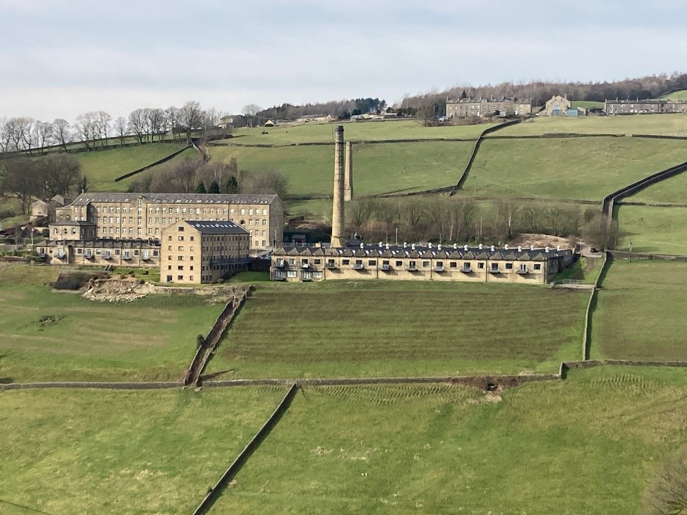
7) Continue along the road to the fine Oates Royd Mill, now converted into flats. The spinning mill is on your left with the weaving sheds on your right.
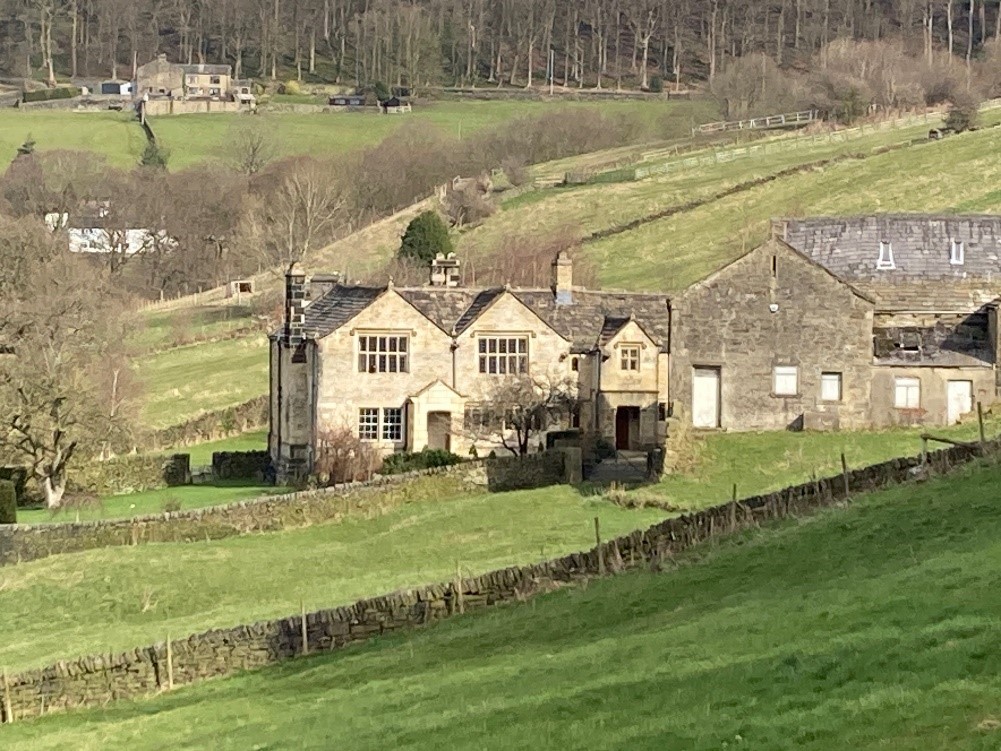
8) Continue along the road past the farm, which also dates back to about 1650 to arrive at the lodge and drive for the largest of the Murgatroyd residences called Broadfold.
This was built about 1860 and by the 1920s, it was said that the ambition of a successor John Murgatroyd was to look from his house and own everything that he could see. He also enjoyed watching cricket, so he provided the field in front of the house for Booth cricket club so he could watch the game from his terrace.
9) About 100 metres past the entry to Broadfold, turn right down Cow Lane. At the bottom turn right and then almost immediately left.
10) Go up the track past Kiln House Lodge to Kiln House Farm. Here you bear right through a gate onto a wide grassy path to the hamlet called Benns Farm. Go up the rough road and fork left to reach the top junction where you turn right down Stocks Lane.
After a few metres you will see on your right over the wall one of the biggest gems of the Luddenden valley – Peel House. This was built in 1598 and is the oldest house still standing in the valley. It contains a hall and at the western end a cross wing.
On this next stretch, there are some fine views of the Luddenden Valley.
11) After 200 metres, at an old lodge, tum left along Buttress Lane. After 300 metres, you will see Hartley Royd (go past it to get the best view).
This was built during the first half of the 17th century. The lower part of the house is of inferior stonework and windows, suggesting it was used as a workshop for handloom weaving.
12) Continue along the road to Birch Lane, then tum right down the road.
You will pass Yellow Birch a modern house, built on the site of an old house which fell down whilst being renovated. White Birch, further along on the right dates back to 1654, although the part near the road is of a later date.
13) At the junction, tum right and then almost immediately left down Ive House Lane. (If you wish to shorten the walk, go straight down into Luddenden, tum left at the bottom and follow the road through to the car park).
About 100 metres, you will come across South Ive Farm, which is a mixture of 17th and 19th century but which also contains timber frames in the walls of late mediaeval date.
14) Continue along Ive House Lane above the houses to a stream, and a walled path to Shepherd House.
This is said to date back before 1624, although there was probably a house on the site before that. It was the birthplace and home of two Thomas Listers, father and son, and both eminent clockmakers. The present house was built by the elder Lister in 1746, and his initials and the date are by the window. Thomas Lister junior was the finest clockmaker of his day, and was appointed to look after the clocks at St. Paul’s Cathedral in London. There are two blue plaques on the wall to celebrate their achievements.
15) Continue down to the junction next to some dilapidated farm buildings on the right down the hill. 50 metres further on and look back to see a grand house called Roebucks, which has recently been renovated.
This dates back to 1633, and consists of a hall and cross wing, but a previous house here was mentioned in 1491. Again, the windows and detail of the lower part suggest that it was used as a workshop.
The owner in 1593 was Michael Foxcroft, who had borrowed some of the money to pay for the estate from his brother-in-law Samuel Wade. Wade claimed the money was not paid back on time, and claimed the house as his. There were a number of lawsuits and fights with “swords, daggers, pikes, axes and saws”. Samuel Wade was stabbed and killed by Foxcroft’s son, who somehow evaded any punishment. The matter finally ended
up at the High Court in Westminster, where one of Foxcroft’s supporters, Thomas Oldfield stabbed Henry Farrer (Wade’s friend) to death in Westminster Hall. He was immediately found guilty of murder, and hung a week later, possibly at Tower Hill. Six years later, Foxcroft was found drowned in the river Calder (cause unknown).
16) Continue down the track, turn right down the tarmac road called Danny Lane. At the bottom, opposite the old library, tum right along
the main road. Take second right up Luddenden Lane. About 400 metres up the road, you will come to Kershaw House on the left.
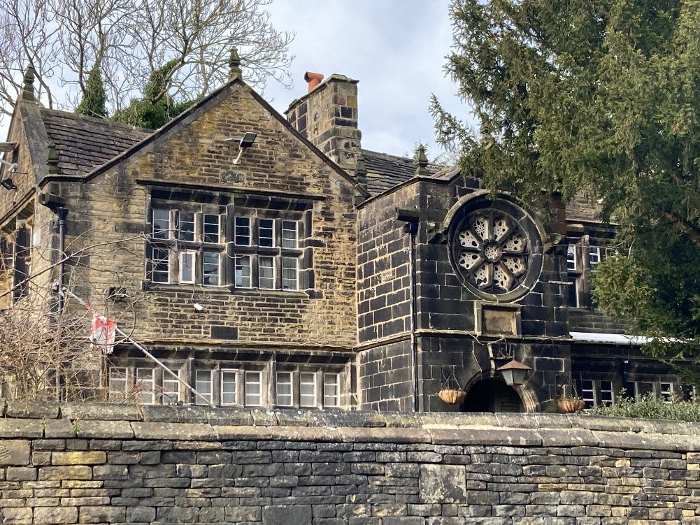
The original name, Kirkshaw House, means the house in, or by, the church wood. No-one knows where this church was, but a licence was granted for a priest to say mass in 1496, which is over 125 years before the first church in Luddenden village. The chapel building at which this was performed is, therefore, possibly the kirk from which the house gets its name.
This house was built by James Murgatroyd in 1634. it is gabled with long mullion windows, has a particularly fine rose window in the porch and an oratory (a room or chapel for private worship) at the rear. In later years, it was occupied by a family which ran a business tanning animal hide, and there were many tanning pits there.
17) Continue along Luddenden Lane for about 300 metres, you will return to the car park from which you started.