
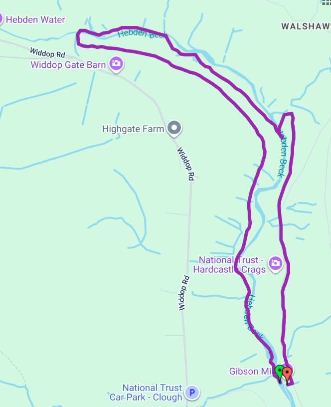
A two way circular walk from Gibson Mill to Widdop Gate
A printable pdf version is available here.
Purple waymark arrows (first and last bit also has green arrows)
Length and time
3½ miles (4½ km or about 8,000 steps). Should take you about 2 hours (plus stops). You need to add time to get to and from the start at Gibson Mill. Probably the most intrepid of all the walks in the Crags.
There is a short cut that will reduce the length by about 1½ km.
Start and finish
Start and finish at Gibson Mill. Get to the mill from the car park at Midgehole – on the track (about ½ hour) or a bit longer on the Riverside Ramble), or from Clough Hole car park on the Widdop Road (½ mile down a steep track).
Highlights
A varied walk through woods, alongside the river and dams with great views along the higher slopes. Watch out for bluebells in the Spring. Part of this route follows the old railway that was used to build the reservoirs on the tops.
Gradients
Probably the most challenging of all the routes. The route includes several steepish uphill and descending sections, as well as 2 relatively flat stretches of riverside path. The final section is a gradual climb and descent on a track to Gibson Mill.
Terrain
The route is mainly on woodland paths. Parts are likely to be wet, especially after rain. Some sections of the path are on very uneven stony surfaces.
Obstacles
There are several sets of uneven stone steps, and a long steep flight of steps at Widdop Gate.
Extending your walk
On the track above Gibson Mill, you can do a quick detour to climb up the top of the Crags (great experience for adventurous children).
When you get back to Gibson Mill, you can walk down the track or take the Riverside path or the Mill Woodland path.

Detailed Directions (clockwise direction)
Link to detailed directions for anti clockwise direction
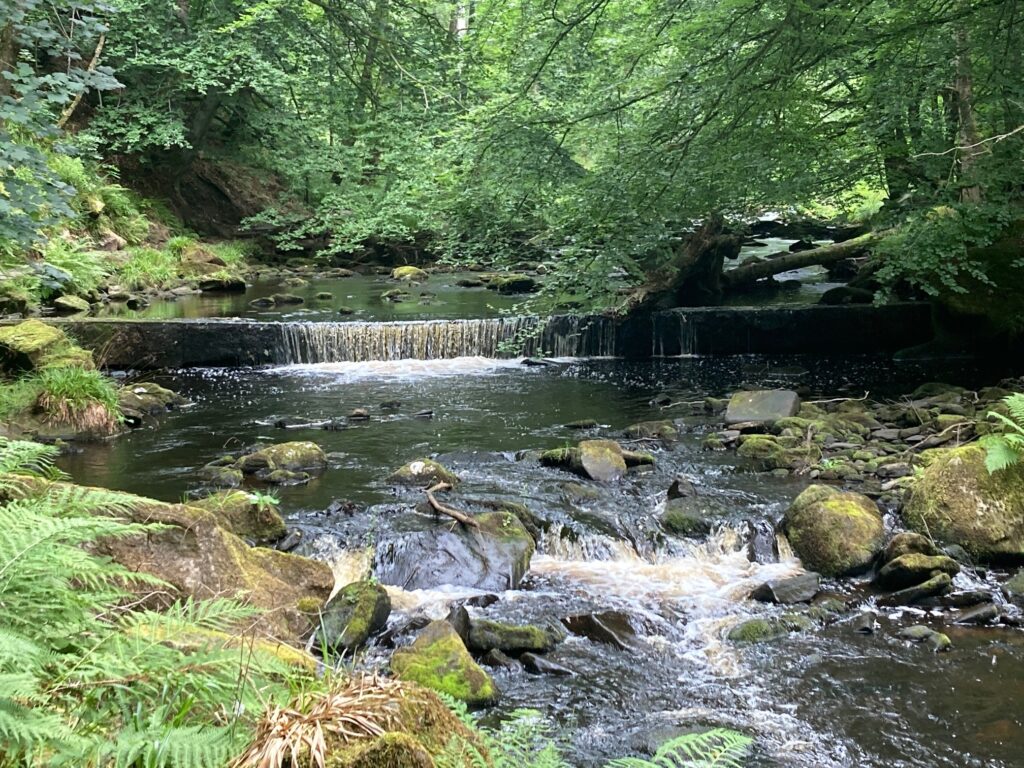
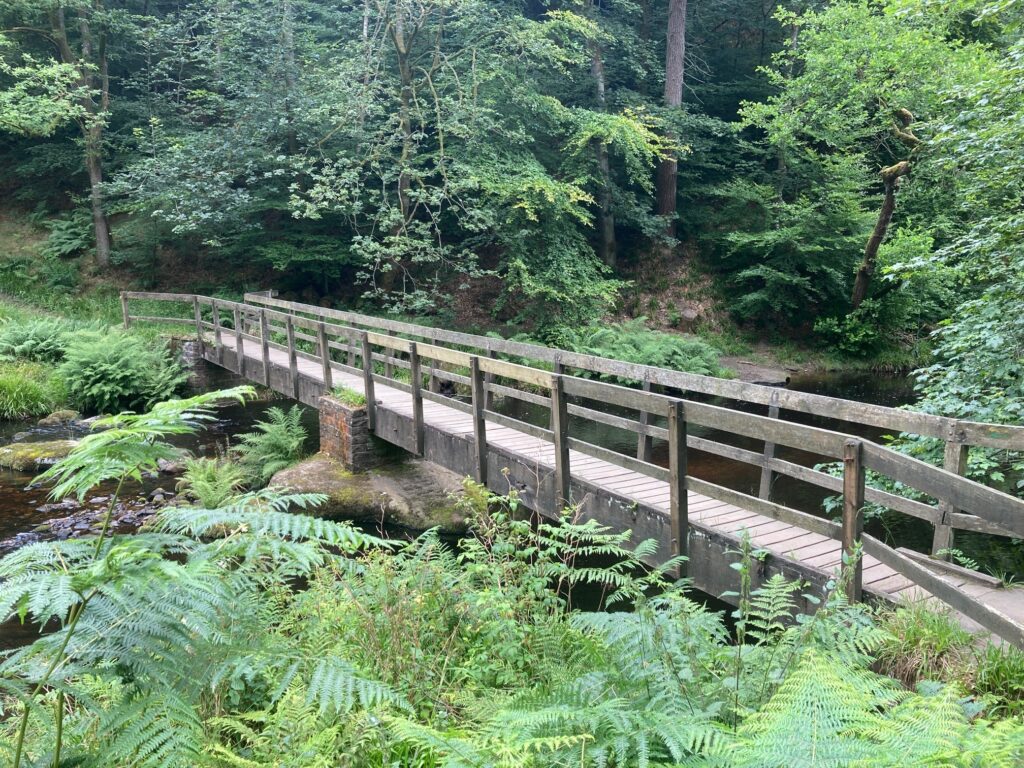
1) From Gibson Mill yard, cross over the bridge and turn right. Cross the stream and then go up some stone steps, then turn right on a narrow path that goes around the mill dam with the stream below you.
2) At the end of the dam, you go on to a delightful stretch of riverside path which is stony and uneven in places. Watch out for dippers wagtails and the occasional heron.
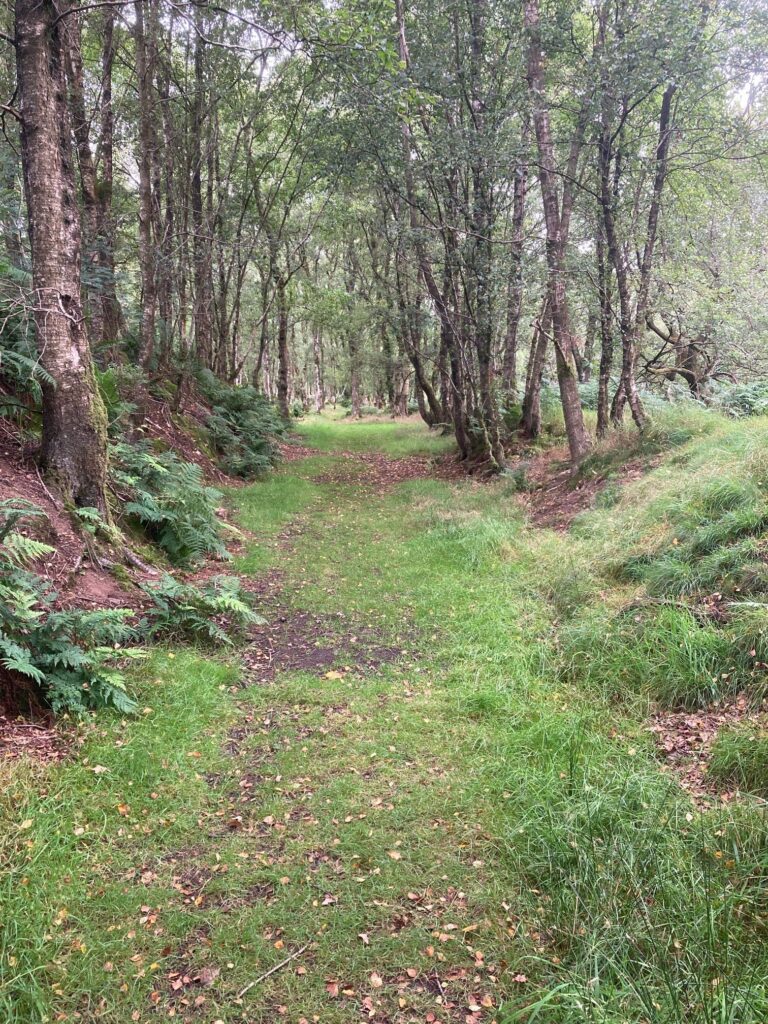
3) At the second huge fallen tree across the river, take the waymarked path going off up to the left away from the river. The path becomes wide and gently climbs up through the trees
A bit about the trees – many old beech trees had reached the end of their life and kept falling over. Beech trees also prevent any growth under them. So the National Trust has selectively felled the area. So you will see trees on the ground and what they call monoliths which are dead trees still standing which are a fantastic habitat for both insects and birds. In a couple of decades’ time all the newly planted trees will have come up and this will look very very different.
4) The path eventually levels out and there are great views looking down on the crags, especially in winter.
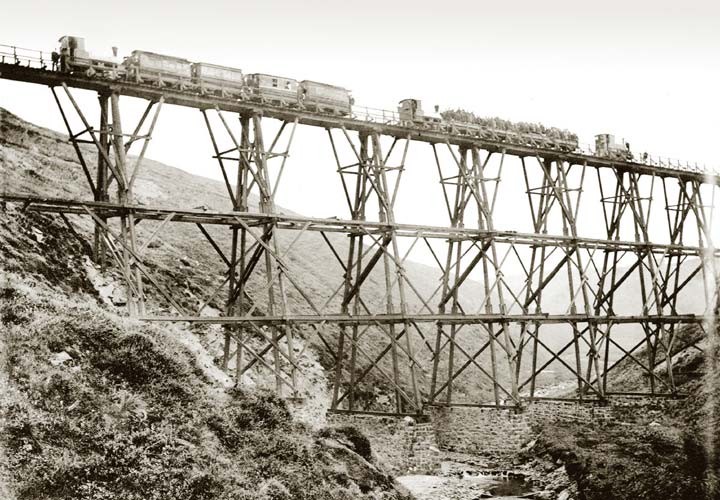
You are now walking along Blake Dean Railway – a narrow-gauge railway, which was built in the early 1900s to transport materials and workers during the construction of the Walshaw Dean Reservoirs. More information about the railway and history of the crags
When you reach a waymark post at a junction, you go straight ahead, but if you want to shorten this walk by about 1 1⁄2 km, you can take the right fork downhill to rejoin the walk at point 11.
5) You will now keep on the route of the railway for about 750 metres. Occasionally the path goes up the bank to avoid some very wet stretches of the old railway.
6) Following an enormous rockfall a short section of the railway bed has disappeared so you have to climb down and then back up the other side to rejoin the original level.
If you look to your left, you will see there is any enormous quarry that was the source of much of the stone for the reservoir
7) A little further on, you reach a second old rock fall where you have to drop down and then climb back up some steps. You then emerge out of the woods with some stunning panoramic views
8) Shortly after you will reach a crossroads where our route turns right down a set of wooden steps to the river.

The route of the old railway line is straight ahead which led to an old trestle bridge across the valley – difficult to imagine.
9) At the bottom of the steps, turn right and follow the riverside path. This is a very quiet section of the river and it’s worth finding a spot and just sitting – you’re sure to see a dipper or a wagtail, maybe a heron.
10) The path has to climb away from the river because of the rockfall mentioned earlier. It then goes back down a set of steps into a woodland dell and the Riverside. And because of the second rockfall, it then goes back up again!
11) At the Path Junction, turn left on a wide path going downhill. When you reach a small stone building, you cross over the bridge and follow the path upward to a junction. Turn right on a wide track heading uphill. If you are doing this in reverse, watch out for this waymarked junction.
12) The track gradually ascends through mixed deciduous woodland with great views of the stream below. The track comes out on to the main Estate Road which you follow gently downhill. If you are doing this in reverse, watch out for this waymarked junction.
13) You reach an open Glade on your left with some picnic tables. Just beyond you will see a finger post on your right signposting ‘To the Crags’
A short diversion to ‘climb the crags’
It’s about a 15 to 20 minute detour to climb to the top of the Crags and back to the track. It is easily doable by adventurous children with an adult in tow.
It starts off with some steps, then you turn right on the level. Then there’s a little bit of scrambling on a clear path to get to the top.
From the top, there are some great views and it is the only place in Hardcastle Crags to send a selfie!
Do return the same way – ignore other routes down that may look promising!
14) Keep descending on the track, a short diversion to look at the mill pond is a must. Then you are back at Gibson Mill.
Detailed Directions (anti clockwise direction)
1) Come out of the yard at Gibson Mill and turn sharp left on the Estate track. After a stretch that gently ascends, you reach an open Glade on your right with some picnic tables. Opposite you will see a finger post on your left signposting ‘To the Crags’. See panel above about a short diversion to the top.
2) Keep going on the track which continues to gently climb. At a waymarked junction, bear left on a track, then through a gate where the track descends through mixed deciduous woodland with great views of the stream below. Just before a bridge, turn left on a waymarked wide rough path which descends to the river.

3) Cross the bridge and take the path up to the right which climbs through woodland. At a junction, turn right downhill to the riverside which you follow for a short distance.
4) The path has to climb away from the river on some steps because of a rockfall higher up. It then goes back down to the Riverside. This is a very quiet section of the river and it’s worth finding a spot and just sitting – you’re sure to see a dipper or a wagtail, maybe a heron.
5) At a waymark post you turn left up a steep set of wooden steps. When you reach a crossroads, you turn left.
To your right is the route of the old railway line which led to an old trestle bridge across the valley – difficult to imagine.
6) You will now walk on the route of the old railway line for about 1 km. Occasionally the path goes up the bank to avoid some very wet stretches of the old railway.
Blake Dean Railway was a narrow-gauge railway, which was built in the early 1900s to transport materials and workers during the construction of the Walshaw Dean Reservoirs. More information about the railway and history of the crags

7) Following two enormous rockfalls, short sections of the railway bed have disappeared so you have to climb down and then back up the other side to rejoin the original level.
8) The wide path then gently descends through the trees
A bit about the trees – many old beech trees had reached the end of their life and kept falling over. Beech trees also prevent any growth under them. So the National Trust has selectively felled the area. So you will see trees on the ground and what they call monoliths which are dead trees still standing which are a fantastic habitat for both insects and birds. In a couple of decades time all the newly planted trees will have come up and this will look very very different
9) The path arrives at the riverside by a huge fallen tree across the river. Turn right and follow the river downstream. This section is a delightful stretch of riverside path which becomes stony and uneven towards the end.

10) You reach a mill dam which you follow around to the end. Go down the stone steps, cross the side stream and arrive at the bridge into Gibson Mill yard.