
A two way walk between the Blue Pig, Slurring Rock and Gibson Mill
A printable pdf version is available here.
(Red waymark arrows)
Length and time
1¼ miles (2km or about 4000 steps). Should take you about 1 hour plus stops.
Start and finish
A linear walk starting at Gibson Mill or the Blue Pig.
Highlights
There are some great views over the Hebden Valley, especially from the spectacular rocky outcrop called Slurring Rock. The route goes through a wonderful stand of pines and you should watch out for some of the local wildlife on this quieter part of the Crags.
Gradients
The first section is quite a long steep climb up to the edge of the woodland. Then an undulating section with a descent at the end.
Terrain
The route is on clear, mainly woodland paths. Many sections of the path are very uneven. Parts can also be slippery or muddy after rain.
Obstacles
There are several sets of rough stone steps.
Getting back to the start
Should you wish to get back to Gibson Mill use either the track or on the Riverside Ramble – allow ½ – 1 hour, depending on which you chose.
From Midgehole you can walk back into Hebden Bridge – a mixture of riverside paths with a short stretch of road.
At Gibson Mill you can do the Crags Constitutional path.
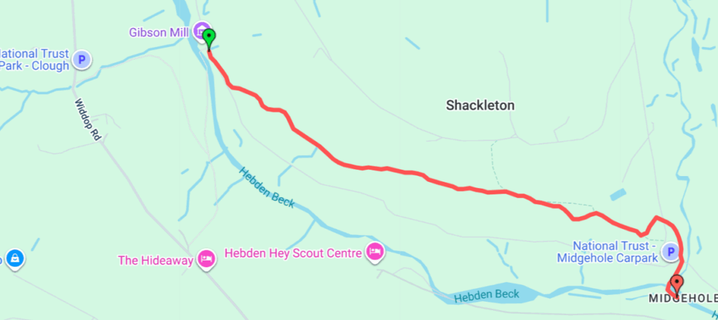
Detailed directions – from the Blue Pig to Gibson Mill
Link to detailed directions from Gibson Mill to the Blue Pig
1) Walk to the end of the car park and turn right on the track over the bridge. At the junction, before the car park turn left and immediately turn right through a gap in the wall on to a bridleway.
2) At the top of the bridleway, turn right on the track and after ten metres take the path off to the left at a waymark post. Follow this path which emerges from the woods and becomes a fine walled causey stone path through fields. This is probably a 17th century route for packhorses. You will sometimes see ponies in the adjacent fields, which is part of a National Trust grazing plan.
3) The path turns left at a small stream crossing and re-enters the woods. It begins to climb, still on the causey path Keep on this until on your left you will see the massive Slurring Rock.
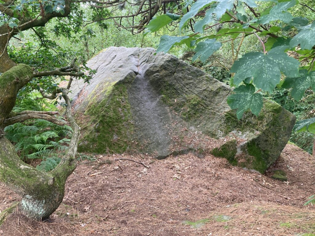
Slurring Rock – look it up on the internet where you will find lots of theories about the origin of its name (nobody knows!)
4) Just after the rock, take the path going off to the left.The path gently descends through mixed woodlands with pine, oak, and Sycamore. Listen out for woodpeckers. Bear right at the first way mark post, the path is a little in distinction places, but at the second waymark post you continue to keep pretty much straight ahead.
5) The path goes through a magnificent stretch of pine woods – this path was created by CROWS about ten years ago. Emerging from the pines, at a waymark post, take the path going up to your right. At the top, you are on a level stretch of path at the top of the woodland running along a fence and then a wall.
6) Continue ahead, at a path junction, take the path up to the left which levels out until you reach a stream crossing which is a good place to listen to the varied Bird song (the Merlin app from Cornell is excellent) and if you stay quiet, you might see one of the many deer that roam the woods.
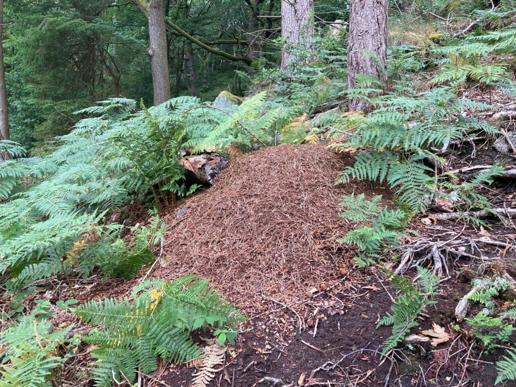
7) You now descend on a rough path with some stone steps. It winds fairly steeply downhill through oak and pine trees. Watch out for the nests of the hairy wood ant on your right.
8) The path emerges onto the main track at a finger post where you turn right. After 100 metres you will arrive at Gibson Mill.
Detailed directions – Gibson Mill to the Blue Pig

1) Coming from Gibson Mill, keep ahead on the wide track going gently uphill way marked midgehole car park. After 100 metres, turn left head uphill at the tall Waymark Post pointing to Mill Walk.
2) The rough path with some stone steps winds fairly steeply uphill through oak and pine trees. Watch out for the nests of the hairy wood ant on your left.

3) Reaching the top at a small stream crossing, why not rest awhile to get your breath, listen to the varied Bird song (the Merlin app from Cornell is excellent) and if you stay quiet, you might see one of the many deer that roam the woods.
4) You now are on a level stretch of path running along the top of the woodland next to a wall and a fence. At a junction, bear right on a level path. As the path begins to descend, bear left at a waymark post. The path takes you through a magnificent stretch of pine woods – this path was created by CROWS about ten years ago.
5) As you come out of the pines, keep ahead on the path which slowly descends. When you reach Way Mark Post, there is a fork, take the rocky path going uphill to the left. The path gently ascends mixed Woodlands with pine, oak, and Sycamore. Listen out for woodpeckers.
6) At another waymark Post, turn left up a short steep stretch of path. At the top at the junction, you turn right downhill and immediately on your right you will see the massive Slurring Rock.

Slurring Rock – look it up on the internet where you will find lots of theories about the origin of its name (nobody knows!)
7) You now head downhill on a fine causey path that is probably a 17th century route for packhorses. The causey stones stop at a small stream crossing, where you bear right on to a walled path that emerges from the woods. You will sometimes see ponies in the adjacent fields, which is part of a National Trust grazing plan.
8) The causey stones reappear, and where the path goes to the left keep alongside the wall. The path emerges onto the track running through the upper car park. Turn right down the main track and almost immediately bear left down a wide path.
9) The path emerges onto a tarmac road through a gap in the wall where you turn left and in about about 20 metres, turn sharp right on a track which descends to a bridge and you then turn left back to the Blue Pig