Written by Michael Denton and illustrated by Jack Denton
We offer two ways to view this walk:
You can print off directions by downloading and printing this pdf file. (17 pages)
Alternatively you can follow the simplified directions below:
This walk is based on the work of Michael Denton who did considerable research on the history of the Luddenden Valley and published this walk in 1985.
In this version of the walk, we have summarised his research, if you want to walk with the full details, use the above pdf file version with comprehensive information that can be printed off.
The history of the Luddenden Dean and the stories of the people who have lived, worked and worshipped there are a fragment of the story of the Industrial Revolution which transformed the whole world. Fortunately, although some of the first seeds of this revolution were sown there, they bore fruit elsewhere and so the valley has been spared the mutilation inflicted by industrialisation.
The walk details
| Distance: 6 km or 4 miles Time about 2½ to 3 hours (including refreshment and view stops, but add extra for the Saltonstall diversion) Paths: mainly on roads and lanes and good footpaths, one section is quite uneven. Strenuousness: there’s two shortish ascents and descents Facilities: Cat ‘ith Well pub – short detour (check opening times). Starting Point: The car park at Jerusalem Farm (O.S. Grid reference 04159 28368) |
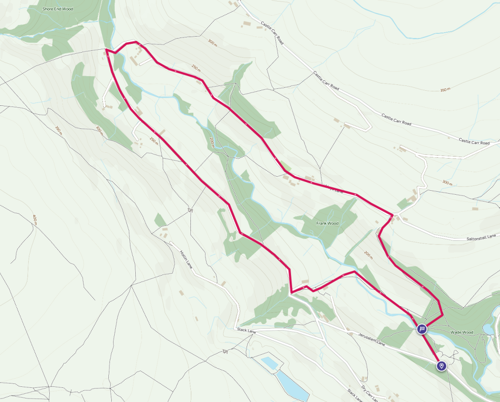
We suggest you take a screenshot of the map to give you easier access during the walk.
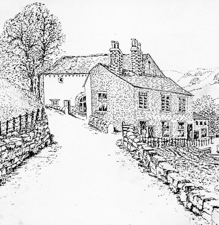
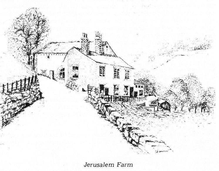
Jerusalem Farm was originally two cottages called Hazel Grove. It now belongs to Calderdale Council and a Community Land Trust, but at one time it was the property of the Midgley family of Booth.
The Midgleys are part of the history of Luddenden Dean and the surrounding area. Booth Farm, just down the road from here, has been in the possession of the Midgley family for over 300 years. The earliest mention of them is in the Wakefield Court Rolls of 1274 and they have owned many of the older properties in the valley.
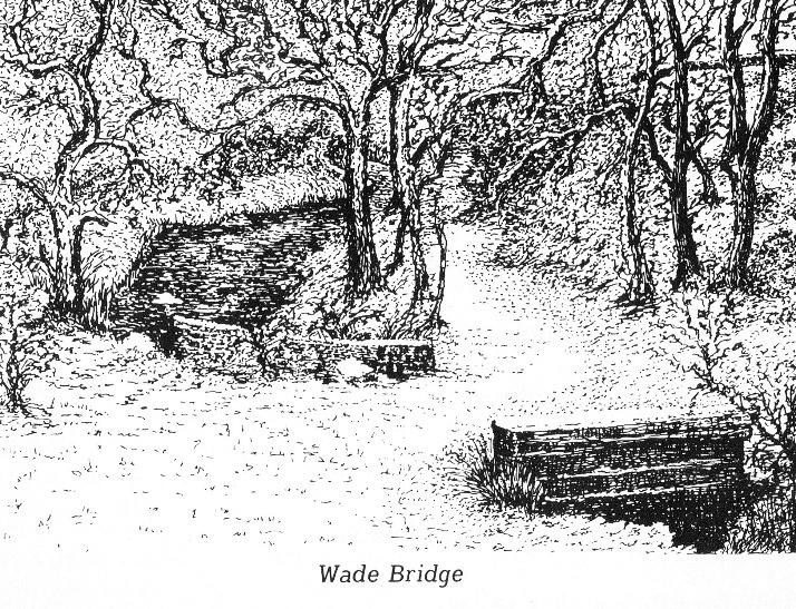
1) From the Jerusalem Farm car park, walk down the track to Wade Bridge which is an old, stone arch bridge path over the stream. Take the ‘Calderdale Way’ waymarked path leading diagonally right up into Wade Wood.
The wood is named after the Wade family who came from Warley. It has many fine old beech trees along with sycamore, birch, oak and holly.
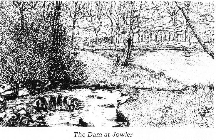
2) When you reach the path on your left waymarked ‘Calderdale Way’ leading diagonally uphill, you can take an interesting, short diversion from the route by going straight ahead up to an old mill dam (now part empty), where there is a fine bench to sit and watch the wagtails. Then re-trace your steps to the Calderdale Way sign.
This is just one of the many dams made about 180 years ago by the mill owners of Wainstalls and Luddenden to control the water to power their mills. Water is collected at Cold Edge Dams on Warley Moor which at one time served several mills, before descending as the Caty Well Brook to Jowler Mill which is just above the dam.
Below Jowler Mill the water from the Caty Well Brook joins the Ludd and once powered a spindle mill at Holme House Bridge. Lower down paper was manufactured using water power at Dean House Mills. Below that, Peel House Mills and Oates Royd Mills all benefited from the power of the water.
Jowler Mill functioned as a textile mill until the 1980’s.
3) At the Calderdale Way sign take the path up through the wood with loads of holly trees. The route then becomes a walled track with another bench with a fine view of Luddenden Dean.
People can still remember cattle being driven from Luddendenfoot Railway Station up to Booth, over the Wade Bridge and up this track to farms higher up the valley. Pause at the bench and you will get a great view of the valley.
Nearly all the farms in the valley were small and the living from them was meagre and so most households had a second source of income by weaving cloth or combing wool. These cottage industries declined as cloth manufacture became mechanised in the new mills that were constructed at Oates Royd, lower down the valley.
4) The track continues up to The Hullett, although its original name ‘Owlet Hill’ is more attractive, go through the gate and walk up the tarmac drive to Heys Lane. Two choices here:
- Turn right if you want a little refreshment and a look at the ancient hamlet of Saltonstall, walk along the road to the Cat ‘ith Well pub at Lower Saltonstall which is about half a mile away.
- If not, go to point 5
The group of buildings at Upper Saltonstall and the history of this area is well recorded as far back as 700 years ago.
A survey made in the reign of Edward II in 1310 records that at Saltonstall there was a ‘vaccary’, or cattle farm belonging to the Earls of Warren and Surrey. The name ‘Stall’ denotes cattle farm and is found in other local place names (Heptonstall, Wainstalls).
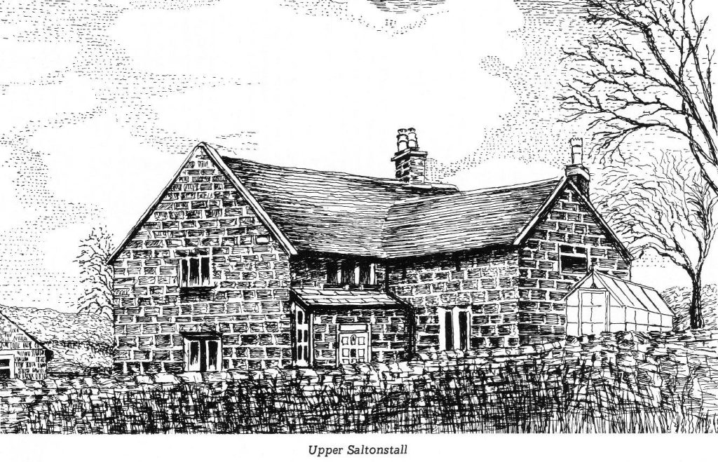
Earl Warren’s retainers took the name Saltonstall and in time the Saltonstalls became a very notable family. Gilbert Saltonstall was one of the Merchant Venturers of the East India Company in the first voyage of 1599, Sir Richard Saltonstall was Lord Mayor of London in I597. A nephew of the Lord Mayor went to America with the Pilgrim Fathers and was one of the founders of Massachusetts.
Richard Saltonstall built a house called the Old Hall at Upper Saltonstall in about 1540 and later in Elizabethan times it was used by Roman Catholics as a meeting place when it was known as “Th‘owd Church”.
At the time of the Cragg Vale Coiners in the second half of the 18th century, two men from Saltonstall were described on a “Wanted” notice. They were said to have instructed men how to clip edges of gold coins and make new ones from the clippings.
The Cat ’ith Well is situated alongside the Caty Well Brook. Behind the Caty high on the hillside are some rocks which are traditionally painted white each May Day, the reason for which is unknown. Inside, have a look for the picture of John Preston who lived in the valley 100 years ago and is mentioned later in the walk.
5) At the top of Hullett Drive turn left walking down the hill along Heys Lane to a cluster of houses called Throstle Bower (with another bench with fine views).
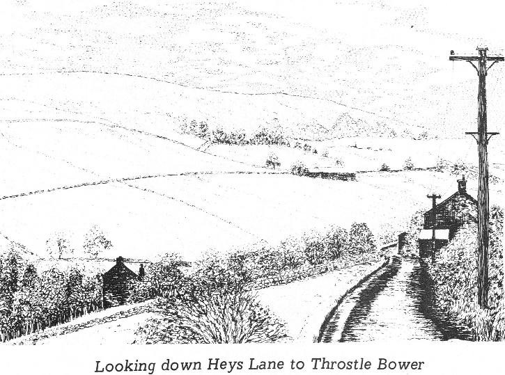
Throstle Bower Farm was built in about 1850 by Thomas Lister. The ruined building at the end of Throstle Bower cottages is the remains of Luddenden Dean Sunday School built in 1878 and pulled apart in the l970‘s.
6) A little further down the road, on the right, is a small graveyard and it is here where Luddenden Dean Chapel used to stand until it was burnt down in 1954. There is a sheltered bench in the graveyard.
The preachings of John Wesley made a great impression upon the hardy, independent people of the Luddenden Valley. A chapel was built in Luddenden village in 1811, but the people of Luddenden Dean wanted a meeting place nearer. In 1820 they started to meet at Head House – a small farm in what was to be Castle Carr estate.
Head House was too small for the growing congregation and so the meeting place was changed to Catherine House Farm.
In 1828, sufficient money had been raised by subscription and so the chapel was built at a cost of £459.
Luddenden Dean Chapel had a very strong following for many years and in 1878 the Sunday School was built nearby.
The chapel burned down in 1954 and so services were transferred to the Sunday School. The congregations declined and it was only on anniversary day that people came flocking back. The trustees eventually sold the building.
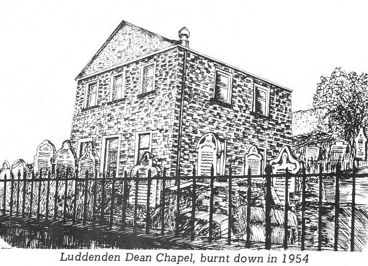
Two of the characters who were preachers at the chapel in its early years were Thomas Greenwood who was also called “Tommy O’ th’ Heys” and Thomas Midgley. Thomas Greenwood was also a farmer and would sometimes deliver his fiery sermons wearing his working clothes and clogs. At one time when he was treasurer, he produced an old teapot at the annual audit from which he poured money. His treasurer‘s report was “Aw’ve put all in theer ‘at aw‘ve drawn and ta’en all a’at ‘at aw’ve paid”.
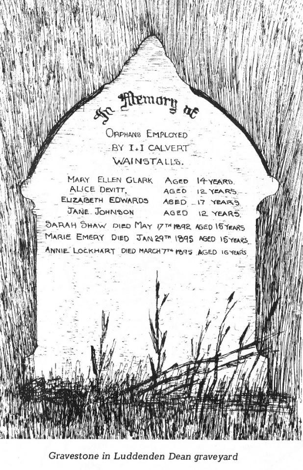
In the graveyard there is one tombstone at the front which is worth a close inspection. It records the deaths of seven children, orphans, who worked at Calverts Mill in Wainstalls. Between 1890 and 1903, 72 girls aged between 11 and 12 were imported into the district from Kirkdale Industrial School, Liverpool, in order to work part-time at the mill. In the school register the mill owner’s name is given as their “guardian”.
7) Walk beyond the chapel graveyard, passing Heys Wood on your right.
Passing another bench at the house called the Nunnery, the next group of buildings is collectively known as The Lowe. In the 1950’s there was a Youth Hostel at the Lowe.
8) Continue beyond The Lowe and the road swings to the left, dropping down to the stone arch bridge over Luddenden Brook. Climb up the track from the bridge and turn left along Catherine House Lane, going under the arch of the lodge of Castle Carr.
A hundred years ago Castle Carr was a magnificent country estate with a mock Tudor castle overlooking lakes and ornamental fountains. Joseph Priestley Edwards of Fixby Hall, Huddersfield engaged architects to design a Tudor Castle which took 12 years to build. The entrance from the carriage drive passed under a fine Norman arch with a portcullis enclosed by a pair of massive, studded oak doors.
There was a grand banqueting hall, a picture gallery, a billiard room, bedrooms, dressing rooms, bathrooms, kitchens, game larders, wine cellars and even a hydraulic lift for taking coals to the upper rooms.
At the centre of the castle complex there was an open, paved courtyard, with a massive stone basin in the centre, complete with a fountain supported by four Talbot Hounds.
Two lakes of ornamental water lay just below the castle surrounded by elaborate, carved stonework and with fountains which played over 100 ft high.
Edwards did not live to see the completion of his dream of a baronial castle in Luddenden Dean, and after his death his son, Lea Priestley Edwards, finished his father’s work.
After a number of changing owners, it was owned by the Murgatroyds until 1949 when it was sold and demolished.
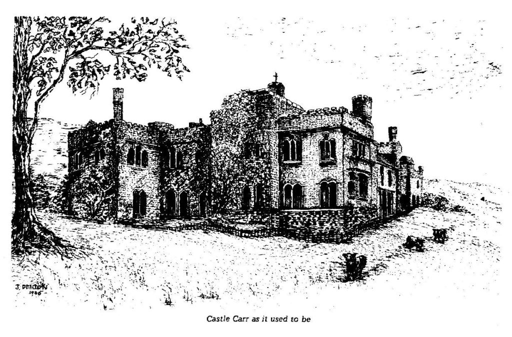
All that remains is the gateway and portcullis, along with the stumps of this once fine structure. The ornamental lakes are still there, but the fountains no longer play, except for occasional charity fundraising events.
9) Continue ahead on the track passing three old dwellings.
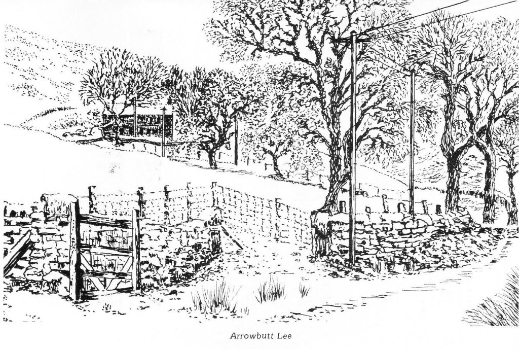
The first house on the right is Arrowbutt Lee. The name ‘Arrowbutt’ suggests that it was where local bowmen practised. An act of 1543 required all men to possess bow and arrows to practice at the Butts.
A little further there is a driveway on the right to a small building called Goose Nest which had a beer licence and was kept by a man called “Daniel o’, Tommy o’, th’, Heys”. It must have been a stop-over for pack horses making their way from Oxenhope to Halifax.
The next farm on the left is Catherine House. It is here that Luddenden Dean Chapel congregation met for seven years before the chapel was built on the opposite side of the valley.
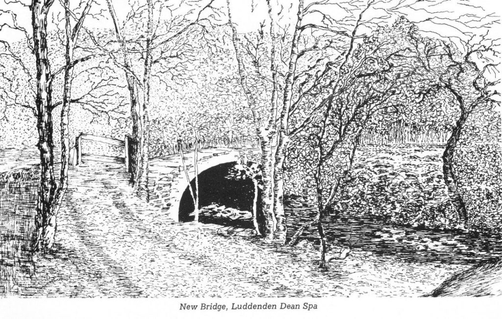
10) Continue along the track from Catherine House and three fields further along, on the left, is a yellow top post marking a footpath which leads down the wall to a squeeze stile. After squeezing through, turn right along the wall and then at a junction head left downhill to the bridge and to what is known as Luddenden Dean Spa. A fine spot for a snack or lunch.
Nearly 100 years ago this was a well-known meeting place. Each first Sunday in May, people would gather from afar to listen to an open-air sermon delivered by a character called John Preston who lived more than 30 years in Luddenden Dean, seldom sleeping in a bed.
The source of his preaching was the Bible, but he would also comment on local affairs and the weather. Several “helpers” would assist in taking the collection which was used to ‘wet the whistles’ of Preston and his helpers at the Cat ’ith Well. There is a photograph of him in the Cat ‘ith Well to this day.
He died from exposure and was buried at Luddenden Dean Chapel where there is a gravestone inscribed, “J.P.”.
11) Retrace your steps to the junction and turn up left to continue following the wall on a narrow uneven footpath. At the third small stream crossing you bear right uphill through the beech trees to the wall corner. When you see the bridleway and a metal gate on your left, look over the wall and there is a stone stile. From the gateway turn left on to the bridleway.
Looking across the other side of the valley you will see another collection of hillside farms. One of these, now derelict, is Upper Green Edge where John Mrgatroyd lived in the early 1800s. This is where the Murgatroyd dynasty started.
John Murgatroyd’s son, another John, left Upper Green Edge in 1835 and set up in business at Paris Gates, Luddenden Dean. John junior bought the Oates Royd estate and built Oates Royd Mill in 1847. Business prospered and buildings were added
The influence of the Murgatroyds had a profound effect on the lives of all who lived in Luddenden Dean.
Within less than 100 years the Murgatroyd family had risen from weavers and farmers to live in a mansion at Broad Fold. They were owners of the Castle Carr Estate and many farms in the Upper Valley. With the decline of the Textile Industry, most of these properties have passed back into separate ownership and the mills stand empty.
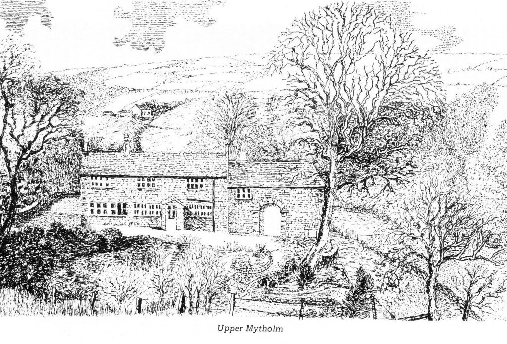
12) As you pass the track on the left going down to Upper Mytholm, take the narrow footpath bearing off to the left. Follow the path above the stream on your left to a house on your right which is Lower Mytholm. You go through stiles and gates down to the Luddenden Brook where you cross a bridge and continue ahead.
Mytholm means “meeting of the waters” and so Upper and Lower Mytholm are above and below the meeting of the stream with Luddenden Brook.
Upper Mytholm was originally a farm with a cottage attached and has the typical mullioned ‘weavers windows’ like so many in the valley.
13) Don’t be seduced by the grassy Riverside Path, take the path going up to the left which runs above the river. Where the path forks, bear right down to a wide gate into Jerusalem farm and you will arrive at Wade bridge, below the car park.