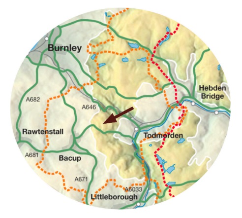
On Todmorden Moor, the geology and archaeology work together to tell a fascinating story. Here we describe the trail which is set out on the ground with markers and interpretation boards – just follow the white-topped posts.
The trail direction is marked with arrows on white discs with a goniatite fossil design. Stick to the marked trail, particularly in the mined areas where deep holes and conical depressions may be former mine shafts.
Below you will find instructions on how to follow the trail. Alternatively you can save and print this leaflet and use that.
TAKE MOOR CARE!
Take care when walking on open moorland. The weather can change suddenly so ensure you have suitable footwear and clothing, food and drink, and a map.
Always follow the Moorland Visitor’s Code:
- Be safe – plan ahead and follow any signs.
- Keep dogs under close control.
- Prevent uncontrolled moorland fires.
- Protect plants & animals and take litter home.
- Leave gates and property as you find them.
- Consider other people.
Todmorden Moor is strewn with the remains of old mining and extraction industries. These can be extremely dangerous. Do not venture into these
remains, especially old mine workings. If you notice any potential dangers to yourself or others notify the appropriate authority. The Coal
Authority has a 24-hour emergency call out service (01623 637429) for public safety issues, including new collapses, unsealed former entrances, spontaneous combustion of coal etc.
THE TRAIL

Length & Time – The trail is approx 5.5 km (3.5 miles) long. Allow about 2 hours to complete it.
Gradients – Medium difficulty with some steep and rough moorland inclines.
Terrain – Several sections on tracks, others over rough moorland, some muddy after rain.
Obstacles – None.
Facilities on the walk – None.
Map – OS Explorer map OL21 South Pennines.
FOLLOWING THE TRAIL
The numbers in the text refer to features of interest explained in more detail on the map. Take a few moments to stop and look at them as you pass.
a) Start location: OS ref SD 912 250, W3W ref ///view.planting.excellent
The walk starts from the first information board at Guide Quarry by the junction of Tower Causeway and the old Flower Scar Road. Park here or near
Sourhall Cottages 500m away.
b) Set off along Flower Scar Road (1) in the direction of Flower Scar Hill which rises steeply ahead. You’ll walk down this hill on your return. After about 100m, the second information board marks the site of a stone crusher, now to be found in Bacup. Powered by ponies, it was used in the 19th and early 20th centuries to crush soft local sandstone into sand for farmhouse floors.
c) Pass two yellow waymarker posts on your right and your left then, about 50m further on, turn left at a white & blue-topped post onto a bridleway (part of the Todmorden Centenary Way). Rounding the hill above farms, look for the tracks and rectangular ponds of the Coal Authority’s Mine Water Treatment Works which are on the other side of the valley above Clough Foot village (2).
d) Further on, you soon see the dome of the Astronomy Centre on Bacup Road. Descend into steep-sided Acre Nook Clough with its high banks of exposed mudstone (often called shale) up to your right. The Six Inch Mine is nearby (3). Cross the stream by the bridge then go steeply uphill to the next ridge. The ruins of Acre Nook Farm are down to your left. The wide stretch of moorland ahead is where the mined area begins.
e) The trail crosses wet ground to reach a small waste heap where you find another information board (4) – the circular & conical depressions on its aerial photograph are collapsed mine shafts, ventilation shafts or bell pits.
f) Follow the white-topped posts towards the next ridge, ignoring any yellow waymarkers on your left. Look for the cigar-shaped depressions running into the hillside. These are the collapsed remains of old entrances to the near-horizontal drift mines. Miners dug drifts into the hillsides to follow a coal seam underground and, when workings became difficult, they abandoned them to start afresh elsewhere.
g) Below the next information board (5), beyond the lane, was Temperleys’ ‘Middle Shop’ works, part of an extensive ceramic pipe industry on Bacup Road. Proximity to Todmorden Moor gave easy access to two important raw materials – coal (the furnace fuel) and the ‘fireclay’ essential for refractory products.
h) Go over the next ridge and walk down towards an electricity pylon. An information board is nearby (6). Walk down past it and cross two footbridges over the channel and wet ground. On the far side, to your left, are the remains of a retaining wall and sluice system.
i) At the gravel track beyond the next rise, a marker post offers you a choice of going left or right. Turning left then immediately right takes you into Clough Head Quarry with its large information board. (Turning right bypasses the quarry, rejoining the trail a short way up the hill.)
j) Walk ahead, keeping near to the quarry face, then turn right onto a track with white-topped posts going up the hill (7). An active Shooting Club meets in the nearby quarry – don’t enter their area! Go right at the next marker post then, after passing a pylon, go left at another marker post which directs you off the made track for a stiff uphill walk over rough moorland following more white- topped posts.
k) At the top, follow the markers past a large standing stone (sadly not an ancient feature!), then cross over Flower Scar Road and turn right along a path running roughly parallel to the road. On a clear day you have a beautiful view of the Yorkshire Peaks.
l) The trail takes you down over rough moorland past more mining remains (8). Turn left along a former mine tramway to reach the next information board at the remains of an entrance to a mine which operated until 1966 (9).
m) Now retrace your steps and follow the tramway uphill (10) to the next information board at the top. The land on your right is pock-marked by collapsed workings and continues to collapse, sometimes into deep shafts. Stay on the tramway!
n) This information board (on the site of Sandy Road Colliery or Spencer’s Pit) contains a brief explanation of coal balls (11). Turn left along Flower Scar Road, following it past an area of peat bog (12). Don’t divert onto any of the turbine access roads.
o) Go ahead on the old road where the gravel track turns sharply left uphill. As you bear left at the top of the hill, you pass two small areas quarried into the hillside. These ‘delfs’ or ‘delphs’, common in this part of the Pennines, were quarried for buildings, roads and walls by farmers holding rights to take stone off the moor.
p) Take a moment to enjoy more far-reaching views, east towards Hebden Bridge & Stoodley Pike and south towards Walsden & Littleborough. Directly ahead on your skyline is Langfield Moor, part of the Special Protection Area for moorland birds. Flower Scar Road runs downhill and eastward to where you started . . . and where you finish this trail.
q) We hope you have had a satisfying and interesting exploration!
FURTHER READING
Riches of the Earth – Over & Under the South Pennine Moors: buy online from Geosupplies, Sheffield
