
Our landscapes
The geology
Nature and Wildlife
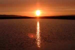
Water
Towns and Villages
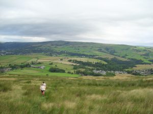
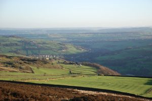
Our varied landscape
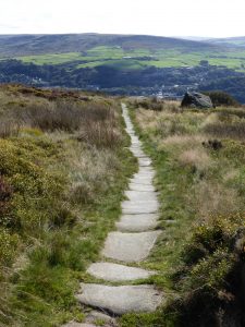
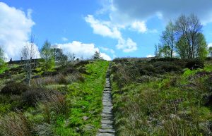
- High heather moorland (1500 feet tops) and big skies.
- Rugged upland pastures with hilltop farms and dry-stone walls.
- Steep sided wooded valleys full of atmosphere.
- Ancient villages with hidden history.
We have a unique combination of landscapes which combined with its early industrial heritage, makes for varied walking. That combined with its early industrial heritage makes for fascinating rambling. The most common comment we get from first time visitors is “we never realised there is this landscape so near northern cities”.
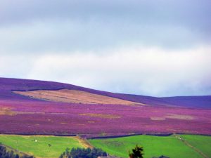
Moorland We have a lot of upland moorland areas known locally as “the tops” where the main vegetation is heather which turns a glorious purple when in full flower in late summer.
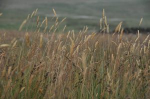
On damper patches there is usually bog bean and sundew and good displays of cotton grass with its distinctive white tufts.
In many places the Bilberry grows and their small berries can be picked to make a tasty pie although patience is required as picking is a slow process!
If you like remoteness, wildness and sometimes bleakness with extensive open panoramas, this is the walking area for you. But it is often breezy and pretty exposed.
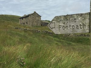
Upland pastures Lower down below ‘the intake’ are grass fields surrounded by drystone walls that are used for grazing sheep, or sometimes cattle, typically over the winter and spring.
Over the summer the farmers will try to get 2 or 3 cuts of haylage or silage to feed to their stock over the harsh winter months. Horses are now widely kept in these fields. Dotted around the fields are buildings that combine the farmhouse and an attached barn.
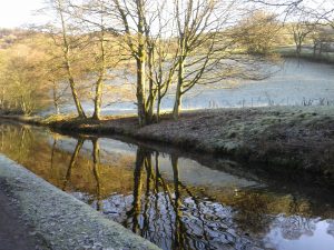
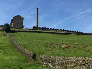
Wooded valleys Coming off the hillsides are many steep sided wooded valleys which drop into the River Calder. This abundance of powerful, fast-flowing stream water was the main reason for the early water powered industrial development of the area. Many of the streams have been ‘captured’ using weirs and an elaborate system of channels to supply the early textile mills. The most famous of these streams runs through the National Trust site of Hardcastle Crags, but equaled by Jumble Hole and Colden Clough.
In the valley bottom the River Calder, the Rochdale Canal, the main roads to Halifax, Burnley and Rochdale, together with the railway are braided routes intertwining and frequently criss-crossing each other in close proximity. The structure of the valley bottom came about because of the needs of the textile industry, but they left pockets of land that has become wild and a haven for wildlife.
The three main towns (Mytholmroyd, Hebden Bridge and Todmorden) are situated in the valley bottom, their origin being a crossing point at a confluence of stream and the River Calder.
If you want too know more about our landscape, you will find some more photos on our blog.
The Watershed project website explains more about the landscape.
The Geology
- Curious outcrops such as Great Rock, Bridestones and the Basin Stone.
- Part of the Pennine ‘backbone’ of England which stretches 250 miles from the Peak District of Derbyshire through the Dales to the Scottish border.
Millions of years ago, when river deltas covered this part of Britain, grit, sand and silt were washed down and deposited here. These became the gritstones, sandstones and shales of the area.
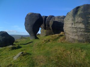
The Pennines were formed by a distant collision of continents. After the uplift, the land would have been much higher than it is now, but the softer rocks on the top were gradually eroded away exposing the harder grit-stones beneath. This has left us with a series of dramatic rock formations.
During successive Ice Ages, glaciers gouged out wide valleys. As the ice retreated, melt-water torrents continued to deepen the Calder Valley leaving us with today’s landscape.
The Millstone Grit and the deposits of limestone left behind by the glaciers have helped to shape the area’s traditional buildings and industries. They have provided stone to build local farms, homes and mills; rocks to build characteristic drystone walls; and limestone for the production of lime used as fertilizer.
West Yorkshire Geological Trust produce some fascinating geology walks and three are in the area:
- Todmorden Moor Geology Trail – a 3.5 mile circular walk with explanation boards along the route.
- Heptonstall – a short walk around the village looking at the rocks, buildings and the landscape.
- Gorpley Clough, (just outside Todmorden on the Bacup Road) – a short stroll up a unique geological valley in the area.
Nature and wildlife
Trees and flowers The attractive native deciduous woodland lining the steep valley sides is a notable feature of the area. Trees include the oak, beech, silver birch, ash, hazel, and in wetter areas willow and alder. In the spring there are fantastic patches of bluebells that you will come across, and foxgloves are frequently seen.
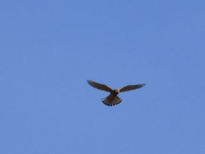
Birds & mammals Walking on the tops you are highly likely to see Curlews with their distinctive long down curved bills and black and white Oyster Catchers.
You will also see Lapwings making their spectacular tumbling aerial display courtship flights with their noisy peewit calls.
There are some birds of prey – plenty of Kestrels, but not as many Sparrowhawks and buzzards as you would expect.
Another common experience on the tops is to hear the Skylark which will serenade from on high with its beautiful cascading song.
A much rarer sight is the illusive Twite which has one of its last strongholds in the area.
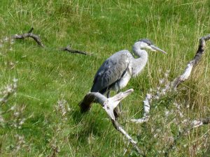
The mammals tend to be rather shy, but if you are quiet and lucky you may encounter roe deer and grey squirrels typically in the woods. Occasional hares and more commonly rabbits may be seen, and there are many foxes about. However you are unlikely to encounter the nocturnal badgers or otters that live locally but are much more secretive, though you may see signs of their presence with badger setts and otter spraints (droppings) near bridges. In the spring you may see and hear frogs and toads when they are more active spawning in ponds, reservoirs and ditches.
Water
Reservoirs and dams On the tops you will find several Yorkshire Water reservoirs supplying the water to the large urban conurbations nearby. You will also come across smaller dams that provided water to top up the canal or provide a guaranteed source of water for the mills in the valley below.
Tumbling woodland streams. The wooded streams tumbling off the hillside are a joy to come across. You will find them in every part of the area. If you look carefully you will see remnants of where the water has been channeled off to water mills downstream. Two of our favourites are Jumble Hole Clough and Colden Clough.
The River Calder starts as large streams at Cornholme and Walsden which join at Todmorden. From there its route was changed in the 19th century to accommodate large dams to feed the mills. It is joined by small streams all the way including Jumble Hole Clough, Colden Clough and at Hebden Bridge it meets Hebden Water at Black Pit.
Between Hebden Bridge and Mytholmroyd it becomes much wider and below Mytholmroyd Cragg Brook flows into it and it becomes more sedate flowing through the flood plain at Brearley to Luddendenfoot.
The river has always been an asset to local industry, but three major floods in the last ten years have made people more ambivalent about its benefit!
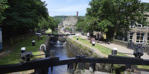
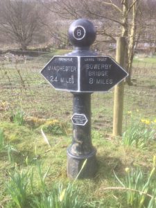
The Rochdale Canal
The beginnings In 1790 a meeting was called in Hebden Bridge to discuss extending the Calder and Hebble Navigation westwards and it was later proposed to take it right through to the Bridgewater Canal in Manchester.
A Rochdale Canal Bill was passed in 1794 and construction began.
By 1799 the canal was open between Sowerby Bridge and Todmorden and from Manchester to Rochdale. A proposed 1.6 mile tunnel was replaced by more locks and a higher summit level at 600 feet. This meant that many reservoirs were required to prevent the summit level drying up and to maintain an available supply of water for the 92 locks.
The canal opened through to Manchester in 1804. This made it the first trans-Pennine canal route. In 1830 a railway surveyed by George Stephenson was proposed, closely following the route of the canal. When the Manchester and Leeds Railway opened in 1841, the canal company had to reduce tolls to retain business.
The decline The canal remained profitable for some time but by the twentieth century the tonnage being carried was in sharp decline. In 1937 the last boat made the through journey across the Pennines on the Rochdale Canal. In the 1950s, many parts of the canal had been abandoned.
The renovation In 1974 enthusiastic supporters re-opened the Canal in Manchester, The Rochdale Canal Society was formed to promote the restoration of the canal and in the 1980s and 1990s small scale work began to re-open stretches of the canal between Todmorden and Sowerby Bridge. This involved restoring bridges and locks to navigable condition.
In 1996 the canal was opened to navigation once again between Sowerby Bridge and Manchester.
For more information look at the Pennine Waterways website
Towns and villages
Here are some short portraits of the main villages and towns to visit when you are in the area.
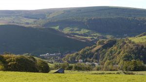
Cornholme & Portsmouth This is a relatively unknown area to walkers from outside the area. There is a good network of ancient packhorse tracks linking the valley floor with the old upland settlements. After a climb up you are rewarded with fascinating geology, quiet wooded cloughs with tumbling rocky streams and impressive panoramic views . If you like dramatic, atmospheric landscapes, full of character then this area is for you. If you plan to visit, we recommend Hills and mills of Cornholme e-trail
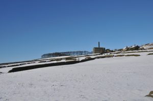
Walsden where you can walk along the summit of the Rochdale Canal or follow the route of the railway tunnel 350ft below. On the tops to the West is Cranberry Dam and the ancient Long Causeway over to Rochdale. On the moors to the East is the Basin Stone – a meeting place for the Chartists in the 1840s and Gaddings Dam – with the highest beach in England. If you plan to visit, we recommend Walsden village walks
Todmorden sits at a T Junction of 3 steep sided upland river valleys. It has an impressive Town Hall, a thriving market, lots of places to eat and drink and a good bus network to get up on to the tops. Not to be missed is Mankinholes, an historic hamlet with a YHA hostel and attractive vernacular buildings and neighbouring Lumbutts with its remains of a former mill waterwheel tower fed by 4 mill ponds. There are several dramatic rock formations around the town, including Whirlaw and the intriguing Bridestones and be sure to visit the iconic Stoodley Pike monument which has a 39 steps spiral staircase up to a balcony offering superb views. The Todmorden Centenary Way is a recreational path created in 1996 that encircles the town. A good way to explore the Todmorden area is Todwalkers bus walks
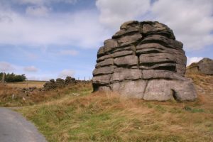
Blackshaw Head This small village sits on the ancient trans-Pennine “Long Causeway” from Halifax to Burnley. It has moorland fringe with upland pasture framed by a high moorland plateau. It’s great walking country, easily accessible by bus. Don’t miss the many 18th century hill top farms, Great Rock, Noah Dale, Hoof Stones Height (nearly 500 metres high) and the wooded Jumble Hole Clough going down to the valley below. If you plan to visit we recommend the Village Walks around Blackshaw
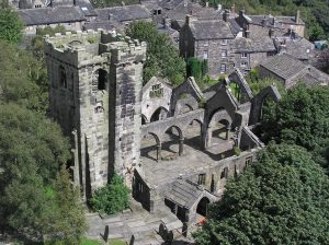
Heptonstall is perched above Hebden Bridge and is one of the oldest villages in the area. The Pennine Way Loop and the Calderdale Way go through Heptonstall, so make sure you allow enough time to explore the village. Pick up a town trail guide from the village Post Office or order a copy of the guide or the Heptonstall e-trail before you visit. Not to be missed are the 18th century octagonal chapel where John Wesley preached, the local museum and the church of St Thomas a Beckett which dates from 1260. Even better, stop off at one of the two pubs or cafe in the village.
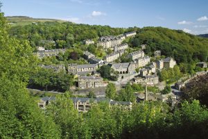
Hebden Bridge is a great hub for walking with paths and bus routes radiating from the centre. Nearby is the National Trust site of Hardcastle Crags with loads of beautiful walks to suit all needs. Not to be missed – the 16th century packhorse bridge, the canal towpath and the flying freehold houses.
If you stay you won’t be short of entertainment- films, plays, music and galleries – and loads of places to eat and drink. An easy way to explore the town is the Hebden Bridge Town Trail
Old Town & Pecket Well both on the tops in the parish of Wadsworth. Nearby to Pecket Well is Lumb Falls which inspired Ted Hughes’ poem Six Young Men, Smeekin Pike war memorial and a converted 19th century fustian mill (and the Robin Hood pub). Old Town is a short hop down the road with another fine 19th century mill and at the far end, the Hare and Hounds pub at Lane Ends. A short climb above these two villages and you are on fine heather moorland, with some fine views. Old Town has the OS kilometre square with the longest length of paths in the country! Hebden Bridge Walkers Action have produced 3 more walks from Hebden Bridge, all of which explore the area.
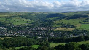
Mytholmroyd just over a mile from Hebden Bridge, with equally dramatic scenery, delightful walks and good transport links. Footpaths abound – along the canal towpath, through dense woodland and across the heather moors. It has a large nature reserve at Broadhead Clough, managed by the Yorkshire Wildlife Trust. Two other claims to fame – the notorious 18th century gang of counterfeiters called the Cragg Coiners and the birthplace of the late poet laureate Ted Hughes who celebrated the local countryside and landmarks in many of his poems. A good way to explore the area is Village Walks around Mytholmroyd
Cragg Vale This valley climbs nearly 1000 feet from Mytholmroyd to Blackstone Edge with easy access to linear walks by bus. It has one of the most wonderful stream-side walks in the area where you will find several interpretation boards describing features and history of the valley. A short climb will give you access to high moors, upland pastures and Withens Clough Reservoir which has an easy circular path around it. Cragg Vale has two great pubs – The Hinchliffe and the Robin Hood. A great way to explore this valley is the Cragg Vale e-Trail together with all the info boards on the route.
Midgley Perched high on the south facing slopes of the Calder Valley with wide ranging Pennine views, Midgley is surrounded by stunning scenery from the sylvan slopes of Brearley Woods to enclosed pasture land and upwards to open grazed moorland with Bronze Age ancient monuments, all served by a vast network of footpaths. Don’t miss the 18th Century stocks and pinfold. The village is well served by bus and is close to Mytholmroyd train station. The Village Walk around Midgley is a good way to explore the area.
The Luddenden valley extends 4 miles from Luddendenfoot, with car parking and good bus links. A stream-side path passes through the ancient Luddenden village, with old mills and non-conformist chapels, and the acclaimed Jerusalem Farm campsite. Alternatively, hilltop moorland routes pass many fine 17th century yeomen’s houses and provide fabulous views. There are interesting interpretation boards throughout the area, and the historic Lord Nelson pub provides excellent refreshment. For more information see Luddenden Conservation Society website There is a great e-Trail that covers both Luddenden and Midgley