- Discover the cradle of the Industrial Revolution which started here with early water and steam powered textile mills.
- Elaborate systems to capture the water in the fast flowing streams.
- Make time to visit the ancient villages of Luddenden and Heptonstall – both packed full of history and charm.
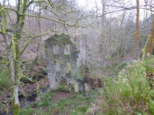
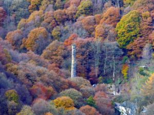
18th century Staups Mill in Jumble Hole Clough
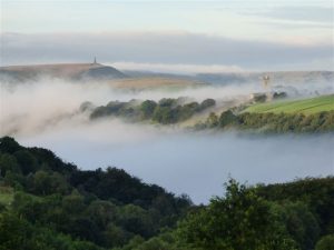
We are rich in history, from medieval deer parks, drovers’ trails and ancient routes across the Pennines. What makes our area most fascinating is that it is where the Industrial Revolution was born, and textile industries thrived. The landscape has been moulded by this industrial heritage, adding an extra layer to your walking experience.
To help you interpret what you are seeing, you may be interested in walking with one of the e-trails produced by Pennine Heritage. You get a printed guide with a downloadable app with images and commentary. Alternatively you can use an experienced Heritage walks guide to explain what you are seeing.
Here is a short run through our history
Prehistoric era
The earliest traces of human activity are middle stone age implements found on the moors at Widdop and Saltonstall. Evidence of Neolitic and Bronze Ages have been discovered along the ancient Long Causeway route from Halifax to Burnley. The progress of development is always found on the tops because the valley bottom was marshy and inhospitable. People would only visit the valley bottom when they had to come down to cross rivers.
By 500 BC climate change and over grazing caused an extension to the peat bogs and the retreat of woodland on the upper slopes.
By 1300 most people living in the area were farming the upper terraces, particularly on the Northern side of the valley. With population increase and no new land to use they had to clear more of the steeper woodland and drain the land.
Middle Ages
The only place mentioned in the Domesday Book is Cruttonstall which is on the Erringden Hillside to the South of the valley (now a derelict farm). During the late Middle Ages, the textile industry developed using the plentiful supply of water for washing the fleeces and later to power the mills. The cloth trade combined with farming produced the ‘dual economy’ managed by wealthy yeoman clothiers.
Piecemeal enclosure of common land continued throughout this period.The cloth was spun and woven in farms who added rows of windows on the first floor, usually facing North. You can still see many farmsteads with these rows of windows.
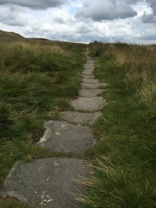
The wool and cloth was transported by pack horses along the old hillside ’causey stone’ routes (more about this on the The history of our paths page).
18th Century
As water power was developed, mills were built to use the upland tributary streams, but factory and domestic production coexisted for several decades. These mills were often pretty big, squeezed into narrow sided valleys. You can still make out a the site of a few of these mills in Jumble Hole Clough and Colden Clough.
The pattern of transport and settlement changed in the mid 18th century. In 1761 work began on a Turnpike Road along the valley bottom and in 1804 after ten years construction the Rochdale canal was completed.
19th Century
The canal meant it was easier to get access to coal, so the textile mills moved from the upland streams down to the valley bottom (where they could be much larger). Many of the old water powered mills limped on, some adding steam power for when the water was scarce, but by the 1880s, they had mainly ceased production as textile mills. The demise of domestic production and the more remote mills resulted in huge depopulation of the uplands, small marginal farms were abandoned, walls crumbled and the moors reclaimed the improved pastures. This process can still be seen all around the landscape today.
The valley bottom was where the work was, so building housing for the workers boomed with the rapid growth of Todmorden, Eastwood, Hebden Bridge, Mytholmroyd and Luddendenfoot. At Hebden Bridge the valley was so narrow that they literally built the houses on top of one another! The railway was squeezed in between the turnpike, canal and river, giving fast connections to Yorkshire and Lancashire.
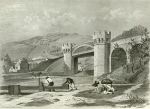
This is From a lithograph by A.F. Tait done around 1850. It depicts the Skew Bridge near Todmorden.
The skew bridge passes over the Rochdale Canal at Gauxholme with a clear span of 101 ft. The castellated abutments of solid masonry were brought from Knowlwood Quarry. This was one of the first bow string bridges in the country.
Photo from The Making of Todmorden
During this period more common land was enclosed by Act of Parliament, their rectangular shapes contrasting with the more irregular patterns of the older fields. When you look at the dry-stone walls you notice that they are all black. This is as a result of the proliferation of mill chimneys in the valley below burning cheap coal!
Back to top
20th Century and today
The textile industry continued to flourish in the first half of the 20th century, but after the second World War, cheaper production in the Indian Sub Continent and under investment by Mill owners made most mills non-competitive. By the 1970s nearly all the textile industry had disappeared (a few small specialist mills continued a little longer). In the 1970s and 80s many of the mills ‘caught fire’ and were pulled down. Some of the mills that survived were converted into flats.
In the 1950s a survey of farming showed that only half of the farms operated full time, most relied on income from elsewhere. This situation has continued, but many farms have amalgamated and farmhouses sold off, renovated and now occupied by ‘off comers’. It has been suggested that the marginal nature of farming has resulted in the landscape and wild life staying more stable that in other areas.
Want to know more?
If you want to explore the heritage of the area on your walks why not come on one of the Heritage Walks where you will be guided by an expert in their field. Or if you prefer to walk on your own, try an e-Trail – providing a map and directions and an optional free audio visual download to your phone.
- E-Trail Power in the Landscape describes the development of water powered mills in the Colden Valley
- Pennine Valley by Bernard Jennings is a great book on the history of the area.